Darmstadt-Arheilgen
| Arheilgen | ||
|---|---|---|
| Stadtteil of Darmstadt | ||
|
Houses in Arheilgen | ||
| ||
 Arheilgen | ||
Location of Arheilgen within Darmstadt  | ||
| Coordinates: 49°54′39″N 8°39′26″E / 49.91083°N 8.65722°ECoordinates: 49°54′39″N 8°39′26″E / 49.91083°N 8.65722°E | ||
| Country | Germany | |
| State | Hesse | |
| Admin. region | Darmstadt | |
| District | Urban district | |
| City | Darmstadt | |
| Area | ||
| • Total | 11.268 km2 (4.351 sq mi) | |
| Population (2011-03-31) | ||
| • Total | 17,122 | |
| • Density | 1,500/km2 (3,900/sq mi) | |
| Time zone | CET/CEST (UTC+1/+2) | |
| Postal codes | 64291 | |
| Dialling codes | 06151 | |
| Website | www.darmstadt.de | |

Arheilgen is a district in the north of the city of Darmstadt in Hesse, Germany incorporated in 1937. Arheilgen borders the Darmstadt district of Wixhausen to the North, to the West is the city Weiterstadt, to the East is the Darmstadt district Kranichstein, to the South is the city center of Darmstadt.[1]
History
The settlement probably began in the second half of the first millennium, when a number of Frankish settlements in the Rhine-Neckar region arose. The first records have an old spelling "Araheiligon", in a register of Abbey Seligenstadt in about 1000.
The Thirty Year War hit Arheilgen hard. On January 1635, the city was burned down by French troops almost completely. Only a few houses remained standing. The surviving inhabitants fled behind the walls of the city of Darmstadt, where many of them died of the plague. By the end of the war in 1648 only about 12 families were left, who set out to rebuild the community.
The chemical element Darmstadtium (atomic number 110) is named after Darmstadt, having been synthetisized in the GSI Helmholtz Centre for Heavy Ion Research in Darmstadt-Arheilgen.[2][3]
Seal and coat of arms
The oldest remaining Arheilgen seal impression dates from 1636. The top half shows the half-figure of Saint Kilian, patron saint of the Franks, the original church was dedicated Arheilger. The Seal includes glasses, a Wolfsangel and two six-pointed stars shown. The origin of these symbols is unknown.
Economy
On the southern part of Arheilgen is the site of the oldest pharmaceutical and chemical company in the world, Merck KGaA. The company is the largest employer in the region. Main agriculture is asparagus.

Station Darmstadt-Arheilgen
Darmstadt-Arheilgen has a Railway platform station. The Station is part of the Main-Neckar Railway and was opened in 1848. The Darmstadt-Arheilgen is station number 1130 and is part of the S3 (Rhine-Main S-Bahn) system.[4][5]

Trams and buses
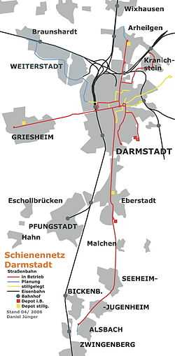
Darmstadt started in 1886 with a steam tram system, that later evolved (with a short period of also including trolleybuses from 1944 to 1963) into a 36.2 km network by 2001.[6] Darmstadt had not scrapped this comparatively extensive network after World War II as many other cities did, though some links were decommissioned in the 1960s and 1970s and replaced by bus lines[6] of which the city also has an extensive network. Tram Lines 6,7, and 8 service Darmstadt-Arheilgen. The central nodal point of the Darmstadt tramway network is the Luisenplatz in the city center of Darmstadt. Buses: Bus WX and 662 also serve Arheilgen. The Bundesautobahn 5 freeway is to the West of town. The main road through town is the A3
Boroughs of Darmstadt
Darmstadt has 9 official 'Stadtteile' (boroughs). These are, alphabetically:[7]
|
|
|
See also
- SG Arheilgen: football club in Darmstadt-Arheilgen.
- FCA Darmstadt: football club in Darmstadt-Arheilgen.
- Darmstadt-Kranichstein Railway Museum
References
- ↑ Google maps Darmstadt-Arheilgen
- ↑ Live like a German web site, Darmstadt
- ↑ GSI Helmholtz Centre web site
- ↑ Facebook page for Darmstadt-Arheilgen Railway station
- ↑ Tripwolf Darmstadt-Arheilgen
- ↑ 6.0 6.1 Darmstadt: A mature tramway grows again – Tramways & Urban Transit, September 2001 issue, pp. 334–336. Accessed 7 December 2010.
- ↑ Statistischer Ueberblick ('Statistical overview', from the official city website, in German)
External links
| Wikimedia Commons has media related to Darmstadt. |
| Wikivoyage has a travel guide for Darmstadt. |
- Official website of the city of Darmstadt (German and parts in English)
- Map of the City of Darmstadt-Arheilgen, with bus and tram stops