Danube–Tisa–Danube Canal
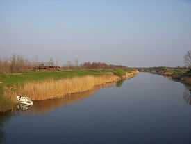

Danube–Tisa–Danube Canal (DTD) (Serbian: Kanal Dunav-Tisa-Dunav/ Канал Дунав-Тиса-Дунав) is a unique hydro-engineering system for flood control and hydrotechnical, amelioration forestry, water supply, waste water evacuation, navigation, tourism, fishing, hunting. It covers the northern part of Serbia - the territory of Vojvodina (Bačka and Banat regions), with the total area of about 12,700 km². It consists of a number of canals, thereof:
The total length of the dug main canals is 929 km, including new and old canals and streams which were completely or partially reconstructed and thus included in the new system. In the basic canal network there are 51 structures - 24 gates, 16 locks, 5 safety gates, 6 pumping stations, and 180 bridges. There are 14 goods ports on the canals. On the new canals of the water system the Danube-the Tisa-the Danube there were built: 84 bridges - 62 carriageway, 19 railway and 3 pedestrian ones. One of the most important structures within this water system is the dam on the river Tisa near Novi Bečej which regulates the water regime in the basic canal network in Banat, for irrigation of about 3,000 km².
External links
- Interactive map of Danube, Sava and Tisa rivers - includes DTD canal
Coordinates: 44°49′35″N 21°20′09″E / 44.82639°N 21.33583°E