Dana, Massachusetts
| Dana, Massachusetts | |
|---|---|
| Town | |
|
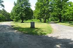
Site of Dana Common | |
| Coordinates: 42°25′19″N 72°13′39″W / 42.42194°N 72.22750°WCoordinates: 42°25′19″N 72°13′39″W / 42.42194°N 72.22750°W | |
| Country | United States |
| State | Massachusetts |
| County | Worcester |
| Incorporated | February 18, 1801 |
| Dis-incorporated | April 28, 1938 |
| Time zone | Eastern (UTC-5) |
| • Summer (DST) | Eastern (UTC) |
| Designated | March 4, 2013 |
| Reference no. | 13000052[1] |
Dana was a town located in Worcester County, Massachusetts. Formed from parts of Petersham, Greenwich, and Hardwick, it was incorporated in 1801, and was disincorporated on April 28, 1938, as part of the creation of the Quabbin Reservoir. Upon disincorporation, most of the town was returned to the adjacent town of Petersham. The majority of the land of the former town is still above water.
As with the nearby town of Prescott, after the disincorporation, houses were moved or razed, but cellar holes remained. Unlike Prescott, the public is only allowed to visit the former town of Dana by foot, as the old narrow road is blocked off to cars. In the town center (which is still somewhat maintained by the Massachusetts Department of Conservation and Recreation), a stone marker has been installed, which reads: "SITE OF DANA COMMON 1801-1938 To all those who sacrificed their homes and way of life (Erected by Dana Reunion, 1996)". The common and a 68-acre (28 ha) area encompassing the former town center has been listed on the National Register of Historic Places.[1]
-
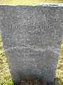
The stone marker mentioned above
-
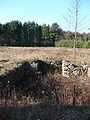
One of the many cellar holes remaining in the former town
Other Quabbin towns
See also
External links
- http://menotomymaps.com/quab_1.html. Map showing the towns buried under Quabbin as they looked in 1912 with original house locations and current reservoir water level.
References
- Tougias, Michael. Quabbin: A History And Explorer's Guide. Yarmouth Port, Massachusetts: On Cape Publications, 2002.)
- ↑ 1.0 1.1 "Weekly list of actions taken on properties: 3/04/13 through 3/08/13". National Park Service. March 15, 2013. Retrieved March 14, 2013.
| ||||||||||||||||||||||||||

| |||||||||||||||||||||||||||||||||||||||||||||||||||||||
