Dalston
Coordinates: 51°32′42″N 0°04′12″W / 51.545°N 0.070°W
Dalston (/ˈdɔːlstən/) is a district of north-east London, England, located in the London Borough of Hackney. It is situated 3.5 miles (5.6 km) northeast of Charing Cross. The area is identified in the London Plan as one of 35 major centres in Greater London.[1] Its historical borders are Kingsland Road and Kingsland High Street in the west, London Fields in the east, Downs Park Road in the north and the Shoreditch parish boundary in the south. Its main shopping street, Kingsland High Street, follows the route of the Roman Ermine Street, and has the road number A10. Modern Dalston is often seen as the area surrounding both sides of Kingsland High Street, even though some of the west side is within the London Borough of Islington.
History
The name Dalston is thought to have derived from Deorlaf's tun (farm)[2] in much the same way as nearby Hoxton was named after the farm of "Hoch".
The village was one of four small villages within the Parish of Hackney (along with Newington, Shacklewell, and Kingsland) that were grouped for assessment purposes, together having only as many houses as the village of Hackney.
John Rocque's map of 1746 shows the village of Kingsland centred on the crossroads at what is now Dalston Junction and the small village of Dalston further east along Dalston Lane.
Around AD 1280 a leper hospital was founded in Dalston by the citizens of London and in AD 1549 it was attached to the chapel of St Bartholomew as an outhouse.
During the 18th and 19th centuries the area changed from an agricultural and rural landscape to urban one. By 1849, it was described as a recently increased suburban village, with some handsome old houses, and by 1859 the village had exceeded its neighbour and, with the railways and continuous building, the village of Kingsland disappeared.[3]
Redevelopment
The gentrification of the area has led to a rapid increase in the price of property. The process of change was accelerated by the East London line extension, now part of London Overground. The reopening of Dalston Junction Station on this extension was part of London's successful bid to hold the 2012 Olympics.[4]
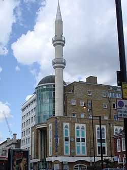
In 1999 the Suleymaniye Masjid was opened to the public. It contains a wedding hall, guest rooms, class rooms, funeral service facilities and many other facilities.
Entertainment
Dalston has always been an important transport and shopping centre. It was also, at one time, an important entertainment centre, with four or five cinemas within a radius of a ⅓ of a mile, and the Dalston Theatre, a former hippodrome and music hall that later became the Four Aces blues club and the Labrynth nightclub. The Dalston Theatre was demolished in February 2007, despite an active local campaign to save it.[5]

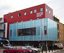
Dalston was a hub for 1970s and 1980s pub rock venues but these are largely defunct. However, the new Dalston Culture House, the first wing of which has opened on Gillett Square, hosts the Vortex Jazz Club, moved from Stoke Newington in 2005.[6]
Notable people
- Stephen Fry and Hugh Laurie shared a house on St Mark's Rise in Dalston in the early 1980s[7]
- Emily Lloyd, actress
- Sir Charles James Martin, FRS, FRCS, director of the Lister Institute of Preventive Medicine
- Alan Spenner- Bass player with The Grease Band and Roxy Music[8]
Shopping

Established in the 1880s, Ridley Road Market is opposite Dalston Kingsland railway station.[9] Fruit and vegetables, some fairly exotic, are available. Halal butchers cluster around the high street end of the market.
Ridley Road market is reputedly the basis for the one found in the BBC's EastEnders.[10] The Kingsland Shopping Centre (formerly Dalston Cross) is just south of Ridley Road market. Kingsland Road and the surrounding streets are home to an ever-growing number of trendy boutiques, bars and cafés.
Area profile

Contemporary Dalston is a lively neighbourhood with an ethnically varied population. Architecturally it is a mixture of 18th and 19th century terraced houses and 20th century council estates. It is currently undergoing rapid gentrification, partly because of the redevelopment of the railway station at Dalston Junction and partly due to the revitalisation of large parts of east London in the build-up to the 2012 Olympics. (Hackney was one of the four host boroughs of the Games.)
Dalston has attracted immigrants for over 100 years; at the turn of the century it was a popular area for newly arrived Jewish people from central Europe. In the 1950s and '60s, as the Jewish community became more affluent and moved out, they were replaced by a large Caribbean community, which accounts for the wide choice of Caribbean food available in Ridley Road. As the Caribbean community slowly drifted out of Dalston it then became popular with the Turkish, as well as the Vietnamese. Recent arrivals include Poles, judging by the numbers of Polish delicatessens now appearing and other stores catering to Polish tastes.
Fassett Square was the inspiration for the BBC soap EastEnders. Originally, there were plans to film the series there, on location. However, Fassett Square (Albert Square) and Ridley Road Market (Walford Market) were rebuilt on the set in Elstree, near Borehamwood, to have a more controlled filming environment. The idea of Walford stems from Walford Road, and many of the houses on the show use the same exterior design. Coincidentally both Barbara Windsor and Tony Holland, one of the original creators of the show, lived at different times on the street.
The Hackney Peace Carnival Mural created in 1985, depicts a group of people marching for peace against "the bomb" and has become an important cultural statement from that era. It can be found opposite Dalston Junction Overground station on Dalston Lane. It has also been used on the cover of an album by local group Rudimental.
That is not the only connection with entertainment industry. Around the corner, music hall artist Marie Lloyd (1870–1922) used to reside on Graham Road. The house now has a blue plaque.
In April 2009 The Guardian published an article on Dalston claiming that it was the "coolest" place to live in Britain.[11] In the same year however, sculpture park The Towers of Hackney was torn down to give way to new buildings.
Pop-culture references

- The 2007 film Run Fat Boy Run (directed by David Schwimmer) was filmed in Dalston (St. Mark's Conservation Area). Dennis (Simon Pegg) stays in a flat on Sandringham Road across the road from St. Mark's Church.
- The third series of popular television show The Mighty Boosh takes place in Dalston.
- Dalston Songs is a staged song cycle with seven singers created and composed by Helen Chadwick and choreographed by Steven Hoggett. It was based on interviews with people in East London about home and was performed in 2008 at the Royal Opera House.
- The Will Self Club believes that after death, its members will be reincarnated to life eternal in Dalston, in line with teachings in their deity's masterpiece How The Dead Live.
- Dalston is the second of 12 placenames associated with London mentioned in an overdubbed choral series on the Lily Allen song "LDN": "Angel, Dalston, Stockwell, Clapton, Soho, Ladbroke Grove...".
- Britney Spears recorded the pop video for the song Criminal in Dalston in September 2011.[12]
- British indie rock band Razorlight recorded a song called "Don't go back to Dalston", featured on their debut album Up All Night.
- Connan Mockasin's song "Forever Dolphin Love" mentions Dalston.
Transport
Dalston has two stations, at Dalston Kingsland and Dalston Junction, both served by London Overground and linking with west and south London. Dalston has no direct rail link to central London; passengers often change at Highbury & Islington station for the London Underground.
From 4 June 2011, bus route 488 was extended to Dalston from its previous terminus at Clapton. [13]
Bus routes serving Dalston in daytime are 30, 38, 56, 67, 76, 149, 236, 242, 243, 277 and 488, and at nights 149, 242, 243, 277, N38 and N76.
Dalston used to have a bus garage on Shrubland Road, now demolished.
 |
Newington Green | Stoke Newington | Shacklewell | |
| Canonbury | |
Hackney Central | ||
| ||||
| | ||||
| De Beauvoir Town | Haggerston | London Fields |

References
- ↑ Mayor of London (February 2008). "London Plan (Consolidated with Alterations since 2004)" (PDF). Greater London Authority.
- ↑ Dalston Junction Environmental Report accessed 30 October 2008
- ↑ Hackney: Dalston and Kingsland Road, A History of the County of Middlesex: Volume 10: Hackney (1995), pp. 28–33 accessed: 7 December 2007
- ↑ "London Overground's East London route doubles passenger numbers in one year". TfL. 7 June 2011. Retrieved 4 January 2013.
- ↑ "Open Dalston campaign"; accessed 27 May 2008.
- ↑ "Who we are…What we do", Vortex; accessed 12 April 2015.
- ↑ Fry, Stephen (2010). The Fry Chronicles: An Autobiography. London: Penguin Books. p. 365. ISBN 978-0-718-15483-7.
- ↑ "Alan Spenner" at BBC Music.
- ↑ "Ridley Road Market". Hackney Council. Retrieved 10 October 2011.
- ↑ Benjamin Hewitt, "Ridley Road Market: The real EastEnders", Hackney post, 19 March 2009.
- ↑ Flynn, Paul (27 April 2009). "Welcome to Dalston, now the coolest place in Britain". The Guardian (London).
- ↑ Staff, Capital FM (16 September 2011). "Britney Spears pulls the 'I love GB' tea trump card". The Sun (London: News International). Retrieved 16 September 2011.
- ↑ "Route 488 extended to Dalston". TfL. 27 May 2011. Retrieved 4 January 2013.
External links
- History of Dalston & Kingsland Road British History Online
- Bombs dropped on Dalston in the Second World War. Bomb Sight.
| ||||||||||||||||||||||||||||||||
