Daintree River
| Daintree River | |
|---|---|
 Daintree River mouth | |
| Origin | Daintree National Park |
| Mouth | Coral Sea |
| Basin countries | Australia |
| Length | 140 km (87 mi) |
| Source elevation | ~ 1100m (3609 ft) |
| Avg. discharge | 40 m³/s (1412 ft³/s) |
| Basin area | 2,125 km² (820 mi²) |
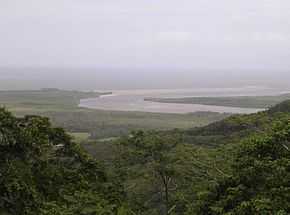
The Daintree River runs through the Daintree Rainforest in the Cape Tribulation region of Queensland in northern Australia. It is located about 100 kilometres northwest of Cairns in far north tropical Queensland and drains an area of 2,125 square kilometres. The river, along with the Daintree Rainforest encircled by it was given Wet Tropics of Queensland World Heritage listing in 1988. The area is now primarily a tourist attraction.
Attraction

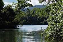
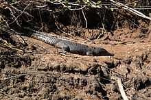
People are drawn to the area for its ancient vegetation, scenic surroundings and the vast array of native wildlife and plant species that inhabit the area. Currently, there is no bridge to enable crossing the river, so access is limited to the Daintree River Ferry, a commercial ferry that traverses the river for the purpose of tourism. Other features that surround the river include Black Mountain, Daintree Range, Thornton Peak and the Cape Tribulation Rainforest. The Daintree River is home to a dazzling array of tropical life. It supports saltwater and freshwater marine life, including the saltwater crocodile. The mouth of the Daintree River opens onto a giant sandbar that shifts with each changing tide. The river winds through thick mangrove swamps where the water remains very salty. As it progresses through the rainforest, the water turns fresh. At this convergence point, an abundance of wildlife congregate, particularly fish.
History
Due to the ever-shifting deep centre of the sandbar, entering the Daintree River has always been a problem for ship captains. The area was missed by Captain Cook when passing in the voyage where his ship was wrecked on the Great Barrier Reef. The Daintree River was first discovered in 1873 after Europeans were attracted to nearby regions due to its vast natural reserves of gold. The river was discovered by George Elphinstone Dalrymple, who was the Queensland Gold Commissioner on the Gilbert gold field at that time. He named the river after Richard Daintree, who was an English geologist and the Agent-General for Queensland in London.
World Heritage listing
World Heritage listing was given to the river in recognition of "its outstanding natural universal value as an outstanding example representing; the major stages of Earth's evolutionary history, significant ongoing ecological and biological processes, superlative natural phenomena and as containing important and significant habitats for in situ conservation of biological diversity. The river is part of the much larger Daintree Rainforest, region in Northern Queensland encompassing 894,000 hectres.
Flooding
The river is surrounded by mountains and deep valleys. Combined with the climatic conditions of the area the river is prone to quickly developing floods with little warning due to the high rainfalls on the 1,000 metre high mountain ranges around the catchment and the influence of the cyclonic forces in the adjacent Coral Sea. In March 1996, record flood levels swamped roads and properties throughout the Daintree region. Statistics gathered at the time recorded 606 millimetres of rain falling in 24 hours.
In 2011, two new causeways were completed over Cape Tribulation Road, making the drive mostly floodproof in all but the most severe rain events. In particular, the notorious bottleneck at Cooper Creek was raised three metres.
Indigenous population
The Kuku Yulanji is the indigenous people who once inhabited the regions surrounded by the Daintree River. The tribespeople were hunter-gatherers who lived in groups of eight to twelve, camping along the banks of the river and living on a staple diet that included a selection of bush tucker harvested from the vegetation from the forest surrounding the Daintree. It has been estimated that the tribe resided on the banks of the Daintree river for over 9,000 years.
Flora and fauna
The river and its surroundings are home to some of the most primitive forms of animal and plant life in the world. The surrounding mountains and valleys provided protection from the forces to adapt to climate change by sheltering several species of plants. A notable example is the primitive She-oak Gymnostoma australianum. This pine-like tree is the only remaining species in the Gymnostoma group of plants in Australia, and is now restricted to very isolated pockets north of the Daintree River. The genus was once widespread throughout Gondwana, and its relatives are still found in parts of the Pacific and south-east Asia.
Of the five species of ringtail possum found in north Queensland rainforests, the Cinereus ringtail possum (Pseudochirulus cinereus) is almost wholly restricted to the Daintree catchment. Within the park, this species is found only in upland rainforest on Thornton Peak and the upper reaches of the Daintree and Mossman Rivers. Once considered a light-coloured form of the Herbert River ringtail possum, commonly found throughout the Atherton Tablelands, it was described as a distinct species in 1989. Black and white Striped possums (Dactylopsila trivirgata) are quite common throughout the park, particularly in the coastal lowlands north of the Daintree River, although to see one while spotlighting requires a mixture of luck and know-how.
Due to the river's isolation, saltwater crocodiles - once threatened in the region due to hunting - have flourished in recent years, beneficiaries of legislation that protects them. There have been numerous reports of deaths in the Daintree River from crocodile attacks, so it is important not to step close to the riverbank, or stay within the confines of boats, and absolutely never swim in the river.
See also
References
External links
 Media related to Daintree River at Wikimedia Commons
| ||||||||||||||||||||||||||||||||||||||||||||||||||||||||