dBZ (meteorology)
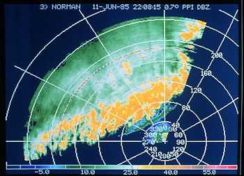
dBZ stands for decibel relative to Z. It is a logarithmic dimensionless technical unit used in radar, mostly in weather radar, to compare the equivalent reflectivity (Z) of a radar signal reflected off a remote object (in mm6 per m3) to the return of a droplet of rain with a diameter of 1 mm (1 mm6 per m3).[1] It is proportional to the number of drops per unit volume and the sixth power of drops diameter and is thus used to estimate the rain or snow intensity.[2] With other variables analyzed from the radar returns, it will help to determine the type of precipitation, too.
Principle
The radar reflectivity (Z) of a cloud is dependent on the number (N) and size (D) of reflectors (hydrometeors), which includes rain, snow, graupel, and hail. It is expressed by:[2]
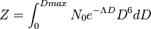
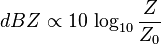
As rain droplets have a diameter of the order of 1 millimetre, Z is in mm6m−3 (μm3), a quite unusual unit. By dividing Z with the equivalent return of a 1 mm drop in a volume of a meter cube (Z0) and using the logarithm of the result (because the values vary greatly from drizzle to hail), one obtains the dimensionless quantity dBZ:
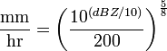
dBZ values can be converted to rainfall rates in millimetres per hour using this formula:[3]
| dBZ | R (mm/h) | Rate (in/hr) | Intensity |
|---|---|---|---|
| 5 | 0.07 | < 0.01 | Hardly noticeable |
| 10 | 0.15 | < 0.01 | Light mist |
| 15 | 0.3 | 0.01 | Mist |
| 20 | 0.6 | 0.02 | Very light |
| 25 | 1.3 | 0.05 | Light |
| 30 | 2.7 | 0.10 | Light to moderate |
| 35 | 5.6 | 0.22 | Moderate rain |
| 40 | 11.53 | 0.45 | Moderate rain |
| 45 | 23.7 | 0.92 | Moderate to heavy |
| 50 | 48.6 | 1.90 | Heavy |
| 55 | 100 | 4 | Very heavy/small hail |
| 60 | 205 | 8 | Extreme/moderate hail |
| 65 | 421 | 16.6 | Extreme/large hail |
Other quantities
The definition of Z above shows that a large number of small hydrometeors will reflect as one large hydrometeor. The signal returned to the radar will be equivalent in both situations, so a group of small hydrometeors is virtually indistinguishable from one large hydrometeor on the resulting radar image. The reflectivity image is just one type of image produced by a radar, using it alone a meteorologist could not tell with certainty the type of precipitation and distinguish any artifacts affecting the radar return.
In combination with other information gathered by the radar during the same scan (dual polarization products and phase shifting due to the Doppler effect), meteorologists can distinguish between hail, rain, snow, biologicals (birds, insects), and other atmospheric phenomena.
References
- ↑ "Weather Glossary: D's". NWS JetStream. Retrieved 2014-02-21.
- ↑ 2.0 2.1 M. K. Yau and R. R. Rogers (1989). Short Course in Cloud Physics, Third Edition. Butterworth-Heinemann. p. 304. ISBN 0750632151.
- ↑ "NWS NEXRAD". Retrieved November 7, 2010.
| ||||||||||