Dôme du Goûter
| Dôme du Goûter | |
|---|---|
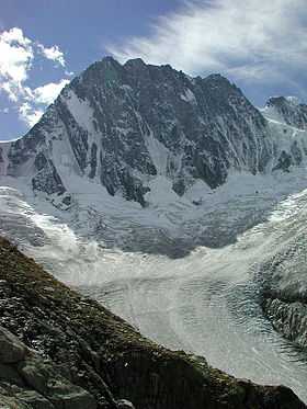
 Mont Blanc (centre left) and the Dôme du Goûter (right) | |
| Elevation | 4,304 m (14,121 ft) |
| Prominence | 58 m (190 ft)[1] |
| Location | |
 Dôme du Goûter Alps | |
| Location | Haute-Savoie, France / Italy |
| Range | Graian Alps |
| Coordinates | 45°50′34″N 6°50′36″E / 45.84278°N 6.84333°ECoordinates: 45°50′34″N 6°50′36″E / 45.84278°N 6.84333°E |
| Geology | |
| Type | Granite/Porphyry |
| Climbing | |
| First ascent | 17 September 1784 by Jean-Marie Couttet and François Cuidet |
| Easiest route | From Refuge du Goûter, 3,817 m, (F) |
The Dôme du Goûter (4,304 m) is a mountain in the Mont Blanc massif. It is a shoulder of Mont Blanc, whose summit lies two kilometres to the south-east. The Dôme is traversed on ascents of Mont Blanc via the Bosses route.
The summit of the Dôme is marked as lying entirely within France on the French Institut Géographique National (IGN) map , although on Italian Istituto Geografico Militare (IGM) map the summit appears to lie on the frontier between France and Italy.

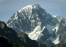
The summit of the Dôme du Goûter