Czerwonków
| Czerwonków | |
|---|---|
|
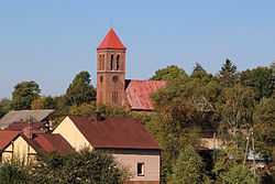
Church | |
 Czerwonków | |
| Coordinates: 50°7′15″N 17°57′11″E / 50.12083°N 17.95306°ECoordinates: 50°7′15″N 17°57′11″E / 50.12083°N 17.95306°E | |
| Country |
|
| Voivodeship | Opole |
| County | Głubczyce County |
| Gmina | Gmina Baborów |
| Time zone | CET (UTC+1) |
| • Summer (DST) | CEST (UTC+2) |
| Area code(s) | +48 77 |
| Car plates | OGL |
Czerwonków [t͡ʂɛrˈvɔŋkuf] is a village in Opole Voivodeship, Głubczyce County, Gmina Baborów.
Before 1945 the area was part of Germany (see Territorial changes of Poland after World War II).
| ||||||||||||