Czarna Góra, Lesser Poland Voivodeship
| Czarna Góra | |
|---|---|
| Village | |
|
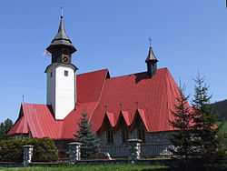
Church of the Transfiguration | |
 Czarna Góra | |
| Coordinates: 49°23′11″N 20°7′59″E / 49.38639°N 20.13306°E | |
| Country |
|
| Voivodeship | Lesser Poland |
| County | Tatra |
| Gmina | Bukowina Tatrzańska |
| Population | 1,506 |
| Website | http://www.gmina.bukowinatatrzanska.pl/index.php |
Czarna Góra [ˈt͡ʂarna ˈɡura], (Slovak: Čierna Hora) is a village in the administrative district of Gmina Bukowina Tatrzańska, within Tatra County, Lesser Poland Voivodeship, in southern Poland, close to the border with Slovakia. It lies approximately 5 kilometres (3 mi) north of Bukowina Tatrzańska, 17 km (11 mi) north-east of Zakopane, and 77 km (48 mi) south of the regional capital Kraków.[1]
The village has a population of 1,506.
It is one of the 14 villages in the Polish part of the historical region of Spiš (Polish: Spisz).
References
| Wikimedia Commons has media related to Czarna Góra, Lesser Poland Voivodeship. |
| ||||||||||||
