Cymmer, Rhondda Cynon Taf
| Cymmer | |
 |
|
 Cymmer |
|
| OS grid reference | ST0290 |
|---|---|
| Principal area | Rhondda Cynon Taf |
| Ceremonial county | Mid Glamorgan |
| Country | Wales |
| Sovereign state | United Kingdom |
| Post town | PORTH |
| Postcode district | CF39 |
| Dialling code | 01443 |
| Police | South Wales |
| Fire | South Wales |
| Ambulance | Welsh |
| EU Parliament | Wales |
| UK Parliament | Rhondda |
| Welsh Assembly | Rhondda |
|
|
Coordinates: 51°36′54″N 3°23′49″W / 51.61492°N 3.39692°W
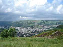
Cymmer is a village and community in the Rhondda Valley, Wales. The area has historically been considered a district of the village of Porth, though prior to the establishment of Porth as the main urban settlement in the area, the position of both communities were largely reversed, Cymmer being so named because of being located at the 'confluence' of the Rhondda Fawr and Rhondda Fach river valleys. Cymmer comprises the sub districts of Glynfach and Britannia. Neighbouring settlements are Trebanog and Llwyncelyn. As a community Cymmer is comprising the villages of Trehafod, Trebanog, Britannia, Glynfach and Cymmer itself.
Several collieries were sunk in the vicinity of Cymmer, namely - Cymmer Colliery (Old No. 1 Pit) (1847), Glynfach Colliery (1851), New Cymmer Colliery (1855), Upper Cymmer Colliery (1851) and Ty-Newydd Colliery (1852), not to mention the several other collieries of Porth and Trehafod. It was the site of an 1856 mining accident in which 114 were killed.
Amenities
There are three different schools in Cymmer: Cymmer Infant School, Cymmer Junior School and Ysgol Gyfun Y Cymer. Cymmer offers facilities for young people; there are youth clubs for both Welsh-speaking and English-speaking teenagers. There are 4 pubs: The Colliers, The Rhondda Hotel, the Cymmer Club and the Pioneer Club.
External links
| ||||||||||||
