Cyfrwy
| Cyfrwy | |
|---|---|
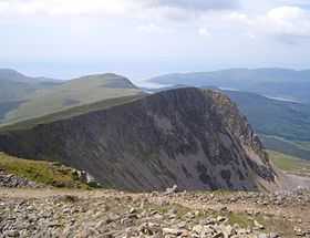 Cyfrwy from Cadair Idris with Tyrrau Mawr behind | |
| Elevation | 811 m (2,661 ft) |
| Prominence | 36 m (118 ft) |
| Parent peak | Cadair Idris |
| Listing | Hewitt, Nuttall |
| Location | |
| Location | Gwynedd, Wales |
| Range | Cadair Idris |
| OS grid | SH711130 |
| Topo map | OS Landranger 124, Explorer OL23 |
| Climbing | |
| Easiest route | Hike |
Cyfrwy is a subsidiary summit of Cadair Idris in the Snowdonia National Park, in Gwynedd, northwest Wales. It lies to the west of Cadair Idris and is often climbed with Cadair Idris by taking the Pony Path.
The summit is bare an rocky and marked with a cairn. The north and east face has large cliffs. A rock climb/extreme scramble known as the Cyfrwy ridge is found here. This ridge is very steep and rope and rock climbing skills will be needed. To the east is Tyrrau Mawr and Craig-y-llyn, while to the south is Craig Cwm Amarch.[1]
References
- ↑ Nuttall, John & Anne (1999). The Mountains of England & Wales - Volume 1: Wales (2nd edition ed.). Milnthorpe, Cumbria: Cicerone. ISBN 1-85284-304-7.
External links
 Media related to Cyfrwy at Wikimedia Commons
Coordinates: 52°41′58″N 3°54′25″W / 52.699428°N 3.907032°W