Cyclone Tomas
| Category 4 severe tropical cyclone (Aus scale) | |
|---|---|
| Category 4 (Saffir–Simpson scale) | |
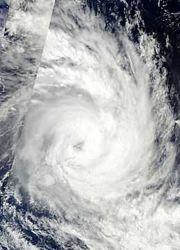
 Cyclone Tomas near peak intensity off the coast of Vanua Levu, Fiji | |
| Formed | March 9, 2010 |
| Dissipated | March 20, 2010 |
| (Extratropical after March 16, 2010) | |
| Highest winds |
10-minute sustained: 185 km/h (115 mph) 1-minute sustained: 215 km/h (135 mph) |
| Lowest pressure | 925 mbar (hPa); 27.32 inHg |
| Fatalities | 3 total |
| Damage | $45 million (2010 USD) |
| Areas affected | Fiji |
| Part of the 2009-10 South Pacific cyclone season | |
Severe Tropical Cyclone Tomas was the most intense tropical cyclone to strike Fiji since Cyclone Bebe in 1972. Forming out of a tropical disturbance on March 9, 2010, designated 14F by the Fiji Meteorological Service, the system gradually organized within an environment favoring intensification. By March 11, the disturbance had strengthened sufficiently to be classified as Tropical Cyclone Tomas, the eighth named storm of the 2009-10 South Pacific cyclone season. Modest intensification took place over the following few days, with the system attaining severe tropical cyclone status on March 13. On March 14, Tomas began to impact parts of Fiji while continuing to gain strength. As it passed near Vanua Levu on March 15, the cyclone attained its peak intensity with winds of 175 km/h (110 mph) and a pressure of 930 hPa (mbar) according to the FMS. At the same time, the Joint Typhoon Warning Center assessed it as a Category 4 equivalent storm with 1-minute sustained winds of 215 km/h (135 mph).
Cyclone Tomas proved to be very destructive throughout Fiji, leaving many homeless and entire villages under water. At least one person has been confirmed to have been killed by the storm after being swept out to sea while rescuing family members. Reports from outlying islands state that entire homes have been flattened by wind gusts up to 280 km/h (170 mph).
Meteorological history

Shortly after the first advisory on Tropical Disturbance 13F was issued on March 9, the Fiji Meteorological Service (FMS) began monitoring a new disturbance, designated 14F, further east.[1] The following day, deep convection began to develop around the disturbance's low-level circulation, prompting the JTWC to begin monitoring it for possible cyclonic development.[2] Later on March 10, the FMS upgraded the system to a tropical depression as it continued to become better organized.[3] Located within an environment characterized by low wind shear, further intensification was anticipated as convection continued to develop over the expanding system.[4] Around 1500 UTC on March 11, the JTWC issued their first advisory on the cyclone, classifying it as Tropical Storm 19P.[5] Several hours later, the FMS upgraded the system to a Category 1 cyclone and gave it the name Tomas. Rapid intensification was expected to take place over the following 48 hours as sea surface temperatures ahead of the storm averaged 30 °C (86 °F), well-above the threshold for tropical cyclone development.[6]
Throughout the day on March 12, Tomas steadily intensified,[7] and early the next day, the JTWC upgraded the storm to a Category 1 equivalent hurricane with winds of 120 km/h (75 mph).[8] Convective banding substantially increased on March 13, allowing Tomas to become the fourth severe tropical cyclone of the season early the next morning.[9] Around the same time, the JTWC assessed the storm to have attained winds of 155 km/h (100 mph), ranking it as a Category 2 cyclone.[8] By the afternoon of March 14, Tomas had developed a banding-eye feature surrounded by deep convection. At this point, the FMS assessed the storm to have winds of 150 km/h (90 mph) and a pressure of 950 hPa (mbar).[10] The JTWC also noted further intensification, upgrading Tomas to a Category 3 equivalent storm.[8] As it passed near Vanua Levu on March 15, the cyclone attained its peak intensity with winds of 175 km/h (110 mph) and a pressure of 930 hPa (mbar) according to the FMS. At the same time, the Joint Typhoon Warning Center assessed it as a Category 4 equivalent storm with 1-minute sustained winds of 215 km/h (135 mph).[8]
Impact
One person was killed on Vanua Levu after being swept out to sea by large swells while trying to rescue her two sisters, a niece and a nephew near Namilamila Bay.[11]
In the northernmost islands of Fiji, communication with Cikobia and Qelelevu was lost on March 15 as the cyclone passed through the region. Officials feared that severe damage and loss of life occurred on the island. Many homes along rivers and the Pacific were washed away by rising waters and tides exceeding 7 m (23 ft). Parts of the region have been soaked with upwards of 350 mm (14 in) of rain over a two day span with more falling. Power and running water was disrupted to numerous islands, forcing thousands to seek shelter. During the initial assessment of damage, at least 50 homes were confirmed to have been destroyed by Tomas. This prompted Fijian officials to declare a State of disaster for the northern and eastern divisions of Fiji.[12][13]
On its way, the cyclone has passed near Futuna island, heavily damaging an important part of houses and other buildings and cutting the water and electricity supply, but leaving no human casualties. The most severed was the north-eastern part of the island and notably the village of Poi and its surroundings. There, the islands only road was washed away and most of the houses were completely demolished by strong wind and rising waves.
After the storm, the governments of New Zealand and Australia each sent $1 million in their respective currencies to Fiji. The New Zealand Air Force sent relief supplies, including tarps and water purifying equipment.[14]
See also
References
- ↑ "Nadi Marine Bulletin for March 9, 2010 at 1800 UTC". Fiji Meteorological Service. March 9, 2010. Retrieved March 14, 2010.
- ↑ "Significant Tropical Weather Outlook for the Western and South Pacific Oceans". Joint Typhoon Warning Center. March 10, 2010. Retrieved March 14, 2010.
- ↑ "Nadi Marine Bulletin for March 10, 2010 at 1800 UTC". Fiji Meteorological Service. March 10, 2010. Retrieved March 14, 2010.
- ↑ "Tropical Depression 14F Advisory A1 and A2". Fiji Meteorological Service. March 11, 2010. Retrieved March 14, 2010.
- ↑ "Tropical Cyclone 19P Advisory NR 001". Joint Typhoon Warning Center. March 11, 2010. Retrieved March 14, 2010.
- ↑ "Tropical Cyclone Tomas Advisory A6". Fiji Meteorological Service. March 12, 2010. Retrieved March 14, 2010.
- ↑ "Tropical Cyclone Tomas Storm Warning Ten". Fiji Meteorological Service. March 12, 2010. Retrieved March 14, 2010.
- ↑ 8.0 8.1 8.2 8.3 Joint Typhoon Warning Center (2010). "Tropical Cyclone 19P (Tomas) Running Best Track". United States Navy. Retrieved March 14, 2010.
- ↑ "Severe Tropical Cyclone Tomas Advisory A13". Fiji Meteorological Service. March 14, 2010. Retrieved March 14, 2010.
- ↑ "Severe Tropical Cyclone Tomas Advisory A15". Fiji Meteorological Service. March 14, 2010. Retrieved March 14, 2010.
- ↑ Vaimoana Tapaleao (March 16, 2010). "Storms fiercer than Katrina batter Fiji and Solomons". New Zealand Herald. Retrieved March 15, 2010.
- ↑ Associated Press (March 16, 2010). "'Few' deaths, 18,000 evacuated as Tomas smashes Fiji". New Zealand Herald. Retrieved March 16, 2010.
- ↑ Commodore J.V. Bainimarama (2010-03-16). "Natural Disaster Management Act 1998: Declaration of Natural Disaster" (PDF). Pacific Disaster.net. Retrieved 2010-03-17.
- ↑ NZPA (2010). "Govt commits $1m to Fiji after cyclone". TVNZ. Retrieved 2010-03-16.
External links
- World Meteorological Organization
- Australian Bureau of Meteorology
- Fiji Meteorological Service
- Meteorological Service of New Zealand
- Joint Typhoon Warning Center
| |||||||||||||
| ||||||||||||||||||||||||||
