Cyclone Katrina–Victor–Cindy
| Category 4 severe tropical cyclone (Aus scale) | |
|---|---|
| Category 2 (Saffir–Simpson scale) | |
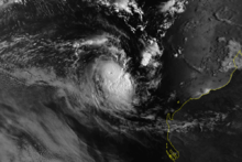
 Satellite image of Katrina on January 13, 1998 | |
| Formed | 1 January 1998 |
| Dissipated |
19 February 1998 (Below tropical cyclone intensity between 25 January and 8 February.) |
| Highest winds |
10-minute sustained: 165 km/h (105 mph) 1-minute sustained: 165 km/h (105 mph) |
| Lowest pressure | 940 mbar (hPa); 27.76 inHg |
| Fatalities | 1 total |
| Damage | $8.66 million (1998 USD) |
| Areas affected | Solomon Islands, Vanuatu, Northern Australia |
| Part of the 1997–98 Australian region, South Pacific and South-West Indian Ocean cyclone seasons | |
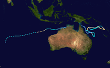
Severe Tropical Cyclone Katrina–Victor–Cindy was a long lived and erratic tropical cyclone, which moved around Australia during parts of January and February 1998.[1] The initial system developed on 2 January and meandered within the Coral Sea between the Queensland coast and Vanuatu for the next three weeks. After its decay the remnants of Katrina moved westward over Cape York Peninsula, past the Northern Territory and into the Indian Ocean where it developed into tropical cyclone Victor during February. Victor was then renamed Cindy by the Mauritius Meteorological Service as it moved into the South-West Indian Ocean.
Meteorological history
During 1 January the Australian Bureau of Meteorology's Brisbane tropical cyclone warning center started to monitor a tropical low, that had developed within the monsoon trough about 630 km (390 mi) to the east-northeast of Cairns in Queensland, Australia.[2][3] Over the next two days the system performed a loop around the Coral Sea and gradually developed further before it was named Katrina by TCWC Brisbane on 3 January after it had become a Category 1 tropical cyclone on the Australian tropical cyclone intensity scale.[2] The JTWC subsequently initiated advisories on the system and then designated the system as Tropical Cyclone 12P as it started to move towards the north-northeast because of the monsoon westerlies located to the north of the system.[2][4] During that day the cyclone intensified slightly further, before all intensification, because the low level inflow was being dominated by Severe Tropical Cyclone Susan as it rapidly intensified.[5][6]
On 7 January, Susan moved further south allowing Katrina to intensify as it neared the Solomon Islands, this proved to be the northernmost point of Katrina's track as the storm turned east-southeast and then southeast, fluctuating in hurricane strength. On 9 January, Cyclone Katrina threatened Vanuatu when it stalled about 200 nautical miles (370 km) west-northwest of Port Vila and reversed direction and moved west due a high pressure system. On 11 January, Katrina moved south of Rennell Island and then crossed back into the Brisbane area six hours later where it crossed the 160E on its eastward journey, then the storm turned west where it maintained that course until 15 January. On the 15th, the storm moved south-southwest where it reached Saffir–Simpson Hurricane Scale Category 2 strength with a barometric pressure of 940 mbar. Katrina weakened rapidly and slowed before making a tight loop on 17 and 18 January.[7] After completing the loop, Cyclone Katrina moved east for 12 hours before moving east-southeast for three days. During that time, Katrina briefly reached Category 1 strength once more before slowing down and being affected by wind shear. By 24 January, Katrina had weakened to a tropical depression and on 25 January, Katrina dissipated 250 nautical miles (463 km) east of Townsville.[7]
Cyclone Victor formed from a tropical low (remnants of Katrina) that passed across northern Cape York Peninsula. The low was weak and poorly structured as it moved to the north of Kimberley during 8 February, however its organization improved significantly on 9 February as it moved west-southwest away from the north Kimberley coast. An LNG tanker reported 40 knot winds near the center during the late afternoon of 10 February and was named Victor that night. It continued to move westward and remained weak during 11 February but intensified during 12 February. An eye became visible during the morning of 13 February as Victor reached peak intensity. Victor continued west-southwest but then progressively weakened. By the morning of 15 February it was sheared with a fully exposed low-level center apparent on satellite imagery.[8] Victor was a small cyclone for its whole lifetime and was surrounded by very high environmental pressures.
As Victor accelerated towards a west-southwestly direction on the edge of a subtropical high, it crossed the 90th meridian east in early 16 February, being briefly renamed by Mauritius as tropical cyclone Cindy.[8] Later that day, the Regional Specialised Meteorological Centre in Réunion (RSMC La Reunion) downgraded Cindy to a tropical disturbance category.[8] Cindy continued to lose its clouds and vorticity until 19 February, when RSMC La Reunion reported that the cyclone dissipated, after having recurved to the south towards a polar through.[8]
The time period from the initial formation of the low in the Coral Sea, until it could no longer be identified as a low in the central Indian Ocean was 51 days.[9]
Impact
Already suffering from the effects of Cyclones Ron and Susan, the South Pacific nations of Vanuatu and Fiji feared additional damage from Katrina as it tracked toward the region.[10]
Australia
After battering some of these islands, the erratically tracking storm reversed direction and threatened another disaster-struck region, Queensland, Australia. By 16 January, officials warned that further rains from the storm could renew floods to regions still recovering from destructive ones earlier in the month. Residents were advised to trim branches off trees, secure outdoor objects, clean their gutters and stock up on emergency supplies. According to press reports, the threat of a landfalling cyclone was, "the worst news for Townsville."[11] Cyclone watches were declared for parts of the Queensland coastline between Cape Melville and Bowen.[12] Cleanup efforts were rushed as debris had to be cleared from flood-stricken areas before the storm struck.[13] On 18 January, the 1,000 relief workers brought into the region after the floods were placed on standby to protect their well-being as the storm moved through.[14] After Katrina stalled and turned away from Queensland on 19 January,[15] the cyclone watch area was revised to encompass areas between Cardwell and Mackay. A strong wind warning was also put in effect from Cairns to Bowen.[16] The following day, these advisories were discontinued as the storm no longer posed a threat to land.[17]
Off the coast of Queensland, Willis Island was impacted by Katrina twice: once on 3 January and again between 16 and 18 January.[15] Both instances brought heavy rains, amounting to storm total of 443.2 mm (17.45 in), more than twice the monthly average.[18] While crossing the Cape York Peninsula, the remnants of Katrina brought moderate rains to the region, exceeding 60 mm (2.4 in) in some areas.[19]
Solomon Islands
Within the Solomon Islands, 450 homes were destroyed on the islands of Rennell and Bellona, while on southern Guadalcanal 200 homes were destroyed as the system brushed the islands.[15] On 15 January, the Solomon Islands home affairs minister declared disaster areas on the islands of Rennell and Bellona and Guadalcanal.[20] The Red Cross and other non-government organizations provided Aid within the islands.[20] The Solomon Islands National Disaster Council subsequently appealed, for further public help and donations to help provide emergency shelter and supplies.[20]
Vanuatu
During 8–9 January, while the system was located within the South Pacific basin, Katrina posed a threat to Vanuatu which had just been affected by Cyclone Susan a couple of days earlier.[21][22] After Susan had moved away, most shops and government buildings on the island of Efate, had kept their shutters up in preparation for the system affecting the archipelago.[23] In Vanuatu, a man drowned after being swept away by large swells and rough seas while fishing.[15]
See also
References
- ↑ Darwin Regional Specialised Meteorological Centre (1998). "February 1998". Darwin Tropical Diagnostic Statement (Australian Bureau of Meteorology) 17 (1): 2. ISSN 1321-4233. Archived from the original (PDF) on 31 July 2012. Retrieved 3 August 2012.
- ↑ 2.0 2.1 2.2 Chappel L C; Bate P W. "The South Pacific and Southeast Indian Ocean Tropical Cyclone Season 1997–98" (PDF). Australian Meteorological and Oceanographic Journal (Australian Bureau of Meteorology) 49: 121–138. Archived (PDF) from the original on 5 June 2011. Retrieved 21 January 2015.
- ↑ Padgett, Gary. Monthly Global Tropical Cyclone Summary January 1998 (Report). Retrieved 21 January 2015.
- ↑ Joint Typhoon Warning Center (3 January 1998). "Tropical Cyclone 12P (Katrina) warning January 3, 1998 03z". United States Navy, United States Air Force. Archived from the original on 4 August 2012. Retrieved 4 August 2012.
- ↑ RSMC Nadi — Tropical Cyclone Centre (22 May 2009). "Best Track Data for the 1997–98 season". Fiji Meteorological Service. National Oceanic and Atmospheric Administration. Retrieved 29 May 2011.
- ↑ Padgett, Gary. "Monthly Global Tropical Cyclone Summary January 1998". Retrieved 1 January 2012.
- ↑ 7.0 7.1 http://australiasevereweather.com.au/cyclones/1998/summ9801.htm
- ↑ 8.0 8.1 8.2 8.3 RSMC La Reunion Tropical Cyclone Center. "Tropical Depression D1". Saison Cyclonique 1997-1998 (Meteo France). Retrieved 17 August 2012.
- ↑ Western Australia Tropical Cyclone Season Summary 1997-98 (Report). Bureau of Meteorology. Retrieved 23 February 2014.
- ↑ Staff Writer (9 January 1998). "New cyclones threaten battered SP islands". The Advertiser. Check date values in:
|accessdate=(help); - ↑ Michael McMahon (16 January 1998). "Cyclone lurks near flooded north". Courier Mail. Check date values in:
|accessdate=(help); - ↑ Staff Writer (16 January 1998). "North set for fury of Katrina". The Daily Telegraph.
- ↑ Louise Brannely (17 January 1998). "City In Fear As Cyclone Moves In". The Daily Telegraph.
- ↑ Greg Abbott (18 January 1998). "Battering Down Again". The Sun Herald. p. 4.
- ↑ 15.0 15.1 15.2 15.3 Brisbane Tropical Cyclone Warning Centre. Tropical Cyclone Katrina (Report). Australian Bureau of Meteorology. Archived from the original on 24 February 2014. Retrieved 24 February 2014.
- ↑ R. Callinan (19 January 1998). "North braces for new cyclone deluge". Courier Mail. p. 2.
- ↑ Staff Writer (20 January 1998). "Katrina threat eases". The Daily Telegraph. p. 6.
- ↑ "Daily Rainfall Summary for Willis Island, Queensland (1998)". Bureau of Meteorology. 2011. Retrieved 8 February 2011.
- ↑ "Daily Rainfall Summary for Wolverton, Queensland (1998)". Bureau of Meteorology. 2011. Retrieved 8 February 2011.
- ↑ 20.0 20.1 20.2 Radio Australia (16 January 1998). "Disaster zones declared in cyclone-hit areas". British Broadcasting Company. – via Lexis Nexis (subscription required)
- ↑ Padgett, Gary. Monthly Global Tropical Cyclone Summary January 1998 (Report). Archived from the original on 24 February 2014. Retrieved 24 February 2014.
- ↑ Tropical Storm. The Gazette (EarthWeek). 17 January 1998.
- ↑ Keith-Reid, Robert (7 January 1998). "Cyclone Susan blows towards Fiji". The Associated Press. Archived from the original on 25 July 2012. Retrieved 10 January 2012.
External links
- Australian Bureau of Meteorology
- Badan Meteorologi, Klimatologi, dan Geofisika
- Fiji Meteorological Service
- Meteorological Service of New Zealand
- Reunion Meteorological Service
- Joint Typhoon Warning Center
- Mauritius Meteorological Service
| |||||||||||||