Cyclone Drena
| Category 4 severe tropical cyclone (Aus scale) | |
|---|---|
| Category 4 (Saffir–Simpson scale) | |
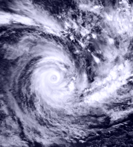 Tropical Cyclone Drena on January 6, 1997 | |
| Formed | January 2, 1997 |
| Dissipated | January 9, 1997 |
| Highest winds |
10-minute sustained: 165 km/h (105 mph) 1-minute sustained: 220 km/h (140 mph) |
| Lowest pressure | 935 mbar (hPa); 27.61 inHg |
| Fatalities | 3 total |
| Damage | $6.7 million (1997 USD) |
| Areas affected | Vanuatu, New Caledonia and New Zealand |
| Part of the 1996–97 South Pacific and Australian region cyclone seasons | |
Cyclone Drena was a powerful tropical cyclone that caused significant damage throughout New Zealand. A tropical depression formed on January 2. After crossing Vanuatu and emerging into the Coral Sea, the storm began to intensify, and by January 6, had attained peak intensity. After attaining peak intensity, Drena began to weaken. Cyclone Drena later brushed New Caledonia, bringing some damage. After transitioning into an extratropical cyclone on January 9, Drena brought impact to New Zealand. Damage totaled to $6.7 million and 3 people were killed. Roughly 140 people were evacuated after 44 homes were flooded. After the season, Drena was retired.
Meteorological history

Drena originated from a low that was first monitored in the monsoon trough. Moving west-southwest and into the Coral Sea, inflow aided development of the low.[1] On January 1, the Joint Typhoon Warning Center (JTWC) recorded that a tropical depression had formed.[2] About 24 hours later, RMSC Nadi announced that a tropical depression had formed near Vanuatu.[3] Meanwhile, the JTWC reported that the depression had intensified into a tropical storm.[2] After intensifying into a Category 1 cyclone on the Australian intensity scale (according to Nadi), and was thus named, Drena re-curved southeast as it interacted with a trough.[1]
On January 6, Nadi reported that Drena had strengthened into a Category 2 cyclone.[3] Around that time, the JTWC reported that Drena had intensified into a Category 1 hurricane on the Saffir-Simpson Hurricane Scale.[2] The next day, according to RMSC Nadi the storm intensified further into a Category 3 cyclone.[3] Simultaneously, the JTWC remarked that Drena had become a Category 2 hurricane. The following day, the JTWC estimated that Drena had strengthened further, into a Category 3 hurricane.[2]
According to Nadi, Drena reached a peak intensity of 105 mph (169 km/h) and a pressure of 935 mbar (27.6 inHg) early on January 6.[3] However, data released by the JTWC indicates that Drena peaked with winds of 145 mph (233 km/h) a day earlier. Moving south-east, the cyclone weakened due to increased wind shear ahead of the trough.[1] By 1800 UTC January 6, RMSC Nadi announced that Drena had weakened into a Category 3 cyclone.[3] Around this time, the JTWC noted that Drena had weakened into a Category 3 hurricane.[2] The following day, the JTWC and Nadi both reduced the intensity of the system to Category 2 status on their respective scales.[2][3]
On January 8, the weakening Cyclone Drena brushed the island of New Caledonia with sustained winds up to 150 km/h (90 mph 10-minute winds).[3] Continuing to weakening, the JTWC claimed that Drena had weakened into a Category 1 system on the Saffir-Simpson Hurricane Scale.[2] Subsequently, Nadi remarked that Drena has weakened into a Category 1 cyclone.[3] While Drena accelerated to the southeast, it weakened further and became an extratropical cyclone near New Zealand on January 9[1] though the JTWC monitored on the system for three additional days.[2]
Preparations and impact
Cyclone Drena brought impact to New Caledonia. Heavy rains accompanied the storm, peaking at 474 mm (18.7 in) in Dzumac. La Foa also recorded 202 mm (8.0 in) of rain. Wind gusts reached 165 km/h (105 mph) in Koumac.[4] Almost all crops were destroyed and many roads were flooded.[5] High winds knocked out power and communication to most of the island.[4][6]
Severe Tropical Cyclone Drena was responsible for damaged roads, property, and agriculture to New Zealand.[7] Overall, damage totaled to $6.7 million (1996 USD). Insurance payouts totaled to $3.2 million. Meanwhile, damage to roads totaled to $2 million and over $1.5 million was down to property.[8] A total of 3 deaths were reported.[8] One man was electrocuted during the storm when he grabbed a fallen powerline when he was climbing up a bank.[9] In addition, An elderly couple died when their car slid sideways into another car on a road.[8] High waves from Cyclone Drena crashed against sea walls along the northern coast of New Zealand.[7]
Roughly 140 people were evacuated at Moanatairi while residents from 20 homes were evacuated at Moanatairi, Te Puru, and Waiomu. A total of 44 homes were flooded and subsequently damaged; 33 of which had soaked carpets and ruined walls and furniture. Considerable damage was recorded on North Island, trees and powerlines were downed and house roofs were lifted. Severe damage was reported in a Northland camp ground. One road was closed for 30 hours. In Auckland City, widespread damage and flooding was reported. Offshore, ferries were cancelled. In Maramarua, around 30 customers were without power for several hours. Several trams were flooded in Waikawau. Several rives were flooded in the Southland. Throughout the island, widespread rains and flooding was reported. In addition. Hauraki Gulf measured winds of up to 160 km/h (99 mph). In Thames, 3.6 m (12 ft) swells were measured. The town of Christchurch received 47 mm (1.9 in) of rain.[8]
After the season, the name Drena was retired from the list of tropical cyclone names.[10]
See also
- Cyclone Bola
- Cyclone Wilma (2011)
References
- ↑ 1.0 1.1 1.2 1.3 Hanstrum, B N; Bate P W. "The South Pacific and Southeast Indian Ocean Tropical Cyclone Season 1996–97" (PDF). Australian Meteorological Magazine (Australian Meteorological and Oceanographic Journal) (Australian Bureau of Meteorology) 48: 121–138. Retrieved May 29, 2011.
- ↑ 2.0 2.1 2.2 2.3 2.4 2.5 2.6 2.7 Joint Typhoon Warning Center; Naval Pacific Meteorology and Oceanography Center. Tropical Cyclone 16P Best Track Analysis (Report). United States Navy, United States Airforce. Retrieved October 30, 2012.
- ↑ 3.0 3.1 3.2 3.3 3.4 3.5 3.6 3.7 RSMC Nadi – Tropical Cyclone Centre, TCWC Brisbane, TCWC Wellington (May 22, 2009). "TCWC Wellington Best Track Data 1967–2006". Fiji Meteorological Service, Meteorological Service of New Zealand Limited, Australian Bureau of Meteorology. United States: International Best Track Archive for Climate Stewardship.
- ↑ 4.0 4.1 "Phénomènes tropicaux ayant le plus durement touché la Nouvelle-Calédonie depuis la fin du XIXe siècle" (in French). Meteo-France. 2009. Retrieved August 5, 2009.
- ↑ (French) New Caledonia Meteorological Office (2011). Cyclone Passes Entre 1950 et 1995: Beni 2003 (Report). Météo-France. Retrieved August 21, 2012.
- ↑ "Earthweek: A Diary of the Planet". Pittsburgh Post-Gazette. January 13, 1997. Retrieved August 5, 2009.
- ↑ 7.0 7.1 Kanchan Ratna Chopra (2005). Ecosystems and Human Well-Being: Policy responses : Finding of responses. Millennium Ecosystem Assessment.
- ↑ 8.0 8.1 8.2 8.3 "January 1997 New Zealand Ex-tropical Cyclone Drena ( 1997-01-10 )". NZ Historic Weather Events Catalog. Retrieved November 2, 2011.
- ↑ "Storms and Cyclones". NIWA. Retrieved November 2, 2012.
- ↑ RA V Tropical Cyclone Committee (March 3, 2009). Tropical Cyclone Operational Plan for the South Pacific and South-East Indian Ocean (PDF) (Report) (2008 ed.). World Meteorological Organization. Archived from the original on 2009-05-21. Retrieved November 6, 2012.
External links
- World Meteorological Organization
- Australian Bureau of Meteorology
- Fiji Meteorological Service
- Meteorological Service of New Zealand
- Joint Typhoon Warning Center
| ||||||||||||||||||||||||||