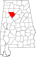
Curry, Walker County, Alabama
| Curry, Alabama | |
|---|---|
| Unincorporated community | |
 Curry, Alabama | |
| Coordinates: 33°57′13″N 87°12′52″W / 33.95361°N 87.21444°WCoordinates: 33°57′13″N 87°12′52″W / 33.95361°N 87.21444°W | |
| Country | United States |
| State | Alabama |
| County | Walker |
| Elevation | 623 ft (190 m) |
| Time zone | Central (CST) (UTC-6) |
| • Summer (DST) | CDT (UTC-5) |
| Area code(s) | 205 |
| GNIS feature ID | 159474[1] |
Curry is an unincorporated community in north-central Walker County Alabama, United States.[1] It is the closest community to the Lewis Smith Lake dam. Curry is served by Alabama State Route 257 which is simply called Curry Highway by locals.
Education
Curry High School is a 5A school, serving grades 9-12.[2] The school colors are Blue and Gold with the mascot being the Yellow Jacket. It is a member of the Walker County Board of Education.[3]
Notable people
- Charles Martin, Alabama politician
References
| |||||||||||||||||||||||||