Currumbin Creek
| Currumbin | |
| Creek | |
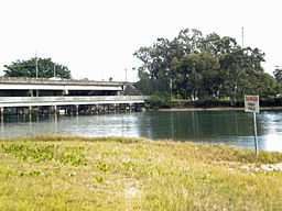 The M1 Highway crossing Currumbin Creek | |
| Country | Australia |
|---|---|
| State | Queensland |
| Region | South East Queensland |
| Source | Mount Cougal |
| Mouth | Currumbin Alley |
| - location | Currumbin |
Currumbin Creek is a large creek on the Gold Coast in Queensland, Australia, running from Mount Cougal in the west to its mouth at Currumbin Alley in the east. It is approximately 24 kilometres (15 mi) in length. It provides a popular and tranquil setting for many rowing clubs, kayakers, jet skiers, boat-goers and fishermen.
Projects
During 2007, a dredging operation took place at the mouth of the creek, making the bottom of Currumbin Alley very shallow, creating a calm lagoon for families and children to play in. Due to a build-up of sand in the creek mouth, not even permitting a jet ski from the creek to the ocean, the Gold Coast City Council announced an operation beginning late in 2008 to deepen the mouth and move sand to the nearby Palm Beach so that beach sand reduced by erosion is replaced.
A boardwalk winds through the small Boree Bodalla Mangrove Reserve with two fishing platforms. It is a popular cycling, running, and walking track and is a serene setting along the creek shore.
Near the creek mouth at Currumbin Alley a swimming canal points northward. It is about 100 metres (330 ft) in length and 30–40 metres (100–130 ft) in width. The demolishment of the Palm Beach Bowls Club cleared way for a grass park and path to the shore of the canal, which is ideal for swimming, unlike many of the bull shark waters and canals further inland.
Currumbin Creek also has an extensive canal system similar to its cousin Tallebudgera Creek and the larger, further north Nerang River. The shores of these canals boast some of the Gold Coast's most prestigious housing.
The City of Gold Coast runs a volunteer Beaches to Bushland restoration program. The Currumbin Creek Care Group established in 2008 helps restore native vegetation in parkland running on the lower areas of Currumbin Creek.[1]
History
The first bridge across the creek was opened in 1926.[2] The road was then known as the Main Ocean Road, later to be upgraded to the Pacific Highway.
See also
References
- ↑ "Beaches To Bushland Volanteer Restoration Program". City of Gold Coast. Retrieved 30 November 2013.
- ↑ Longhurst, Robert (1995). Gold Coast:Our heritage in focus. South Brisbane, Queensland: State Library of Queensland. p. 29. ISBN 0-7242-6563-5.
Coordinates: 28°07′54.56″S 153°28′46.08″E / 28.1318222°S 153.4794667°E