Curral Velho, Paraíba
| Curral Velho | |
|---|---|
| city | |
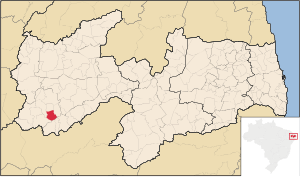 Location of Curral Velho within Paraíba | |
| Coordinates: 07°34′51″S 38°11′52″W / 7.58083°S 38.19778°WCoordinates: 07°34′51″S 38°11′52″W / 7.58083°S 38.19778°W | |
| Country | Brazil |
| Region | Northeast |
| State | Paraíba |
| Micro-region | Itaporanga |
| Founded | 1963 |
| Area | |
| • Total | 181 km2 (70 sq mi) |
| Elevation | 368 m (1,207 ft) |
| Population (2004) | |
| • Total | 2,564 |
| • Density | 14/km2 (37/sq mi) |
| Time zone | UTC-3 (UTC-3) |
| • Summer (DST) | UTC-2 (UTC-2) |
| Postal code | 58990-xxx |
| Area/distance code | (00)55-83 |
| Website | pb.gov.br |
Curral Velho is a municipality in the micro-region of Itaporanga in the Brazilian state of Paraíba. The population in 2007 is 2,781 and the area is 181 km² The elevation is 368 m?.
Other
Palma has only a school or a collegiate, a church and a square. The literacy rate is low.
External links
- http://www.citybrazil.com.br/pb/curralvelho (in Portuguese)