Curbar
| Curbar | |
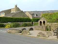 Old well, horse trough and millstones at junction in centre of village |
|
 Curbar |
|
| OS grid reference | SK251746 |
|---|---|
| District | Derbyshire Dales |
| Shire county | Derbyshire |
| Region | East Midlands |
| Country | England |
| Sovereign state | United Kingdom |
| Post town | HOPE VALLEY |
| Postcode district | S32 |
| Police | Derbyshire |
| Fire | Derbyshire |
| Ambulance | East Midlands |
| EU Parliament | East Midlands |
|
|
Coordinates: 53°16′05″N 1°37′26″W / 53.268°N 1.624°W
Curbar is a village in the Derbyshire Dales district of Derbyshire, a mile north of Baslow, close to Calver on the A623.
The village has a street (Bar Road) with the highest average house value in Derbyshire. Close to the east are the popular rock-climbing escarpments of Curbar Edge and Baslow Edge. To the west of the village is the River Derwent. The parish church is dedicated to All Saints.
External links
| Wikimedia Commons has media related to Curbar. |
| ||||||||||||||||||||||