Cunderdin, Western Australia
| Cunderdin Western Australia | |
|---|---|
|
Aerial view of Cunderdin | |
 Cunderdin | |
| Coordinates | 31°40′S 117°14′E / 31.66°S 117.24°ECoordinates: 31°40′S 117°14′E / 31.66°S 117.24°E |
| Population | 681 (2011 Census)[1] |
| Established | 1906 |
| Postcode(s) | 6407 |
| Elevation | 237 m (778 ft) |
| Location |
|
| LGA(s) | Shire of Cunderdin |
| State electorate(s) | Central Wheatbelt |
| Federal Division(s) | Durack |
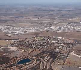
Cunderdin is a town located in the Wheatbelt region of Western Australia 156 km east of Perth,[2] on Great Eastern Highway.
History
The first European visitor to the area was Charles Cooke Hunt, who explored the area in 1864 and recorded the name Cunderdin, from the Aboriginal name of a nearby hill. The meaning of the name is thought to mean "place of flowers".
Like many small towns in the area, Cunderdin developed as a stop-off town during the gold rush in the WA Goldfields. Significantly in 1894 the railway arrived signalling the earliest settlement in the town. Later, in 1901, the Goldfields Water Scheme designed by C. Y. O'Connor led to a renewed increase in population of the town. The townsite was gazetted in 1906.[3]
In 1932 the Wheat Pool of Western Australia announced that the town would have two grain elevators, each fitted with an engine, installed at the railway siding.[4] An elevator was duly erected the following year next to the Westralian Farmers grain-shed.[5]
In late 1933 the local tennis courts were first opened in front of a crowd of about 100 players, a tournament was held the same afternoon. The local hospital also had a X-Ray plant installed and commissioned a week later.[6]
Economy
As part of the wheatbelt, the economy of Cunderdin is primarily agricultural. There is an agricultural college 3 km north of the town; it is one of the six campuses of the Western Australia College of Agriculture. There are approximately 110 students supported by 50 staff and their families.[7]
Cunderdin Airstrip is situated next to the agriculture college.[7] It was built early in the Second World War as a base for the RAAF flying school and bomber base.[8]
Farming
Cunderdin is mostly a farming community. Former Chairman of the WA Colleges of Agriculture, Alan Carter, is one of the many farmers to occupy land in the region. His produce consists of wheat, lupins, canola and also livestock. There is also great livestock production. The Jolma Poll Dorset Stud, run by Perry Jasper and Co., has been very successful when competing in exhibition shows in Perth and Adelaide.
Places of interest
- Cunderdin Museum [9]
- Youndegin, 19 km south of Cunderdin, has the ruins of the earliest settlement in the area
- Cunderdin Hill Lookout – panoramic views of the area
- Railway Water Tower
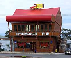
- Ettamogah Pub
- Cunderdin Golf Course, which is situated next to the Cunderdin Reservoir, itself part of the Goldfields water supply scheme
- Cunderdin Pool
- Historic sites of Youndigin and Doodenanning
- Cunderdin Town Oval
- Balga
- Golden Pipeline
- C Y O'Connor Park
Cunderdin daviesia (Daviesiacunderdin) is a small to medium-sized shrub, which grows to 1.6 m high. It appears that it is isolated to the Cunderdin area.[10]
Visitors cannot help but notice the large Ettamogah theme hotel and pub when driving through the town, due to its redness and a car on its roof. It is based on the comics of Ken Maynard and is one of a few of these pubs scattered throughout Australia. There are similar venues in Sydney, Albury-Wodonga,[11] The Sunshine Coast, Queensland and Morley.
Cunderdin also serves as a stop on the Prospector and Avonlink rural train services.
Climate
| Climate data for Cunderdin | |||||||||||||
|---|---|---|---|---|---|---|---|---|---|---|---|---|---|
| Month | Jan | Feb | Mar | Apr | May | Jun | Jul | Aug | Sep | Oct | Nov | Dec | Year |
| Record high °C (°F) | 46.0 (114.8) |
48.0 (118.4) |
43.2 (109.8) |
38.1 (100.6) |
35.0 (95) |
26.0 (78.8) |
25.3 (77.5) |
30.3 (86.5) |
34.7 (94.5) |
38.8 (101.8) |
43.5 (110.3) |
45.6 (114.1) |
48.0 (118.4) |
| Average high °C (°F) | 34.0 (93.2) |
33.3 (91.9) |
30.5 (86.9) |
25.6 (78.1) |
21.1 (70) |
17.7 (63.9) |
16.6 (61.9) |
17.5 (63.5) |
20.4 (68.7) |
24.3 (75.7) |
28.5 (83.3) |
32.0 (89.6) |
25.1 (77.2) |
| Average low °C (°F) | 17.3 (63.1) |
17.5 (63.5) |
15.8 (60.4) |
12.8 (55) |
9.4 (48.9) |
7.4 (45.3) |
6.1 (43) |
5.9 (42.6) |
7.1 (44.8) |
9.3 (48.7) |
12.5 (54.5) |
15.3 (59.5) |
11.4 (52.5) |
| Record low °C (°F) | 7.1 (44.8) |
7.6 (45.7) |
5.0 (41) |
2.2 (36) |
−0.6 (30.9) |
−2.2 (28) |
−3.1 (26.4) |
−1.0 (30.2) |
−0.5 (31.1) |
1.0 (33.8) |
2.3 (36.1) |
4.4 (39.9) |
−3.1 (26.4) |
| Average precipitation mm (inches) | 12.5 (0.492) |
16.4 (0.646) |
19.1 (0.752) |
23.9 (0.941) |
47.5 (1.87) |
63.5 (2.5) |
62.8 (2.472) |
47.3 (1.862) |
27.6 (1.087) |
20.4 (0.803) |
13.5 (0.531) |
10.0 (0.394) |
363.8 (14.323) |
| Avg. precipitation days | 2.0 | 2.4 | 3.1 | 4.9 | 8.9 | 12.6 | 13.8 | 11.6 | 8.3 | 5.7 | 3.5 | 2.3 | 79.1 |
| Average relative humidity (%) | 27 | 31 | 34 | 43 | 52 | 62 | 63 | 58 | 50 | 39 | 32 | 28 | 43 |
| Source: [12] | |||||||||||||
References
- ↑ Australian Bureau of Statistics (31 October 2012). "Cunderdin (L) (Urban Centre/Locality)". 2011 Census QuickStats. Retrieved 2012-10-30.
- ↑ Cunderdin Merredin & Districts Visitor Centre, 2005. Retrieved 11 February 2007.
- ↑ Western Australian Land Information Authority. "History of country town names". Retrieved 2008-09-20.
- ↑ "Country elevators". The West Australian (Perth: National Library of Australia). 6 July 1932. p. 10. Retrieved 6 April 2013.
- ↑ "Country news". The West Australian (Perth: National Library of Australia). 5 July 1933. p. 13. Retrieved 7 April 2013.
- ↑ "Country news". The West Australian (Perth: National Library of Australia). 2 October 1933. p. 14. Retrieved 7 April 2013.
- ↑ 7.0 7.1 Cunderdin Western Australia Police 2007. Retrieved 11 February 2007.
- ↑ Cunderdin www.raaf.gov.au. Retrieved 11 February 2007.
- ↑ An alphabetical list of Museums in the wheatbelt. Merredin & Districts Visitor Centre, 2005. Retrieved 11 February 2007.
- ↑ Cunderdin Daviesia (Daviesia cunderdin) Recovery Plan 1999-2002 Environment Australia, June 1999. Retrieved 11 February 2007.
- ↑ Postcard from the Ettamogah Pub travelsnapz.tripod.com. Retrieved 2007-02-11.
- ↑ "Climate statistics for Cunderdin". Bureau of Meteorology. Retrieved 12 July 2014.
External links
![]() Media related to Cunderdin, Western Australia at Wikimedia Commons
Media related to Cunderdin, Western Australia at Wikimedia Commons
| Preceding station | Transwa Trains network | Following station | ||
|---|---|---|---|---|
towards | Avonlink East Perth – Merredin | towards |
||
| Prospector | towards Kalgoorlie |