Cumbre Vieja
| Cumbre Vieja | |
|---|---|
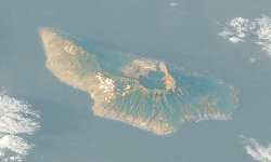
 Satellite photo of Caldera de Taburiente and Cumbre Nueva, La Palma, Canary Islands. (south is above, north is below) | |
| Elevation | 1,945 m (6,381 ft)[1] |
| Location | |
| Location |
La Palma, Canary Islands, |
| Coordinates | 28°34′N 17°50′W / 28.567°N 17.833°W |
| Geology | |
| Type | Stratovolcano |
| Last eruption | 1971[2] |
Cumbre Vieja (Spanish: Old Summit) is an active volcanic ridge on the volcanic ocean island of Isla de La Palma in the Canary Islands, Spain.
This ridge trends in an approximate north-south direction and covers the southern third of the island. Several volcanic craters are located on the summit ridge and flanks.
Volcanic history
La Palma is a volcanic ocean island. It is currently the second most volcanically active of the Canary Islands [3] Historical eruptions on the Cumbre Vieja occurred in 1470, 1585, 1646, 1677, 1712, 1949 and 1971.
1949 eruption
The eruption started on 24 June 1949 - the feast day of St John, which is why in Spanish texts the eruption is referred to as "la erupcion del Nambroque o San Juan," which in English is "The Eruption of the Nambroque or St John's volcano." During the 1949 eruption, three vents —Duraznero, Llano del Banco, and Hoyo Negro —opened and lava flowed from the Duraznero and Llano del Banco vents. Two earthquakes also occurred during the eruption, with epicentres near Jedey. Following the earthquakes a fracture approximately two and half kilometres long, about 1/10 of the exposed length of the Cumbre Vieja, opened and parts of the western half of the Cumbre Vieja ridge moved about 1 metre sideways and 2 metres downwards towards the Atlantic Ocean.[4][5] As of 2008, the fracture is still visible and still has the same dimensions recorded in 1949.
The timeline for the eruption, according to Bonelli-Rubio,[4] is as follows: The first reported seismic activity was noted on the rim of the Caldera de Taburiente on 23rd July 1936, with further activity noted over the next two days. During the following years periodic seismic activity occurred, but due to no monitoring equipment the only reports are those recorded in the media. Then on the 24th June 1949, Duraznero vent opened with mildly explosive activity, venting of gases and rocks with eruptive activity continuing in this manner until 6th July. During this phase a strong earthquake occurred on 1st July and again on 2nd July with an estimated intensity of VII on the Modified Mercalli Scale. Visits to the summit region revealed a crack about 1.5 km (~1 mile) long (this crack is the subject of research and heated debate as to whether it indicates initial failure of the western flank - or not). Later analysis placed the epicentre north of the township of Jedey. No eruptive activity occurred on 7th July. On 8th July eruptive activity commenced as lava is erupted at the Llano del Banco vents and flowed down the western flank. The vents opened progressively up the barranco (ravine), forming a series of en-echelon (diagonally side by side), vents. On 10th July the westward flow of lava from the Llano del Banco vents reached the coast at Puerto de Naos and entered the Atlantic Ocean, forming a lava delta, the velocity is estimated at ~14 metres (approximately 46 feet) per sec. On 12th July mildly explosive activity commenced at the Hoyo Negro (Black Hole) with emissions of rocks, fumes and some phreatomagmatic activity indicating that the eruption encountered ground waters. Activity at the Hoyo Negro ceased on 22 July, but continued at the Llano del Banco vents until 26 July. Only residual fumarolic activity and thermal emissions occurred until 30 July when the Duraznero vent and fissure re-activated. Lava then flowed from the Duraznero vent and fissure, filling the adjacent crater of El Fraile and created a lava lake. This subsequently overflowed and the lava flowed down the eastern flank towards the ocean. It finally stopped about 1 km (about 0.5 mile) from the ocean. Eruptive activity ceased and only residual fumarolic activity continued until 4 August; thereafter there was only thermal emissions. It is estimated that approximately 60 million cubic metres of lava was erupted during the eruption.
This process is considered to have been driven by the pressure caused by the rising magma super-heating water trapped within the edifice of the volcano. It is unlikely that the trapped waters could vapourise due to being under considerable pressure. What is postulated is that the waters were heated to a point where they could not absorb further thermal energy in the available space. Continuing heating required the water to expand further and the only way it could do so was to move the flank of the volcano. This resulted in the two earthquakes that were reported as occurring during the eruption.
That the entrapped (within the edifice) water did not vapourise is shown by the absence of phreatomagmatic explosions: steam escaping explosively from the ground is often a precursor of volcanic activity. Further evidence that vapourisation did not occur is that when Rubio Bonelli visited the rift the following day, the newly opened fissure "... Was not issuing fumes, vapour, steam, ashes, lava or other materials ..."[4] In fact at no time during or after was steam or phreatomagmatic activity reported. This reinforces the claim that the waters trapped within the edifice never vapourised, which they would do if the pressure had fallen sufficiently to allow the super-heated water to flash into steam. Only at the Hoyo Negro did any phreatomagmatic activity occur.
1971 eruption
The 1971 eruption occurred at the southern end of the Cumbre Vieja at the Teneguia vent. The eruption was mainly strombolian in style. Lava was also erupted. Such seismic activity did not occur during the 1949 eruption. Residual thermal activity continues.
Future threats
BBC's Megatsunami
In October 2000, the BBC aired “Mega-tsunami; Wave of Destruction”,[6] which suggested that a future failure of the western flank of Cumbre Vieja would cause a "mega-tsunami".
Day et al. (1999)[7] and Ward and Day (2001)[8] hypothesize that during an eruption at some unascertained future time, the western half of the Cumbre Vieja—approximately 500 km3 (5 x 10¹¹ m3) with an estimated mass of 1.5 x 10¹⁵ kg—will catastrophically fail in a massive gravitational landslide and enter the Atlantic Ocean, generating a so-called 'mega-tsunami'. The debris will continue to travel along the ocean floor as a debris flow. Computer modelling indicates that the resulting initial wave may attain a local amplitude (height) in excess of 600 metres (2,000 ft) and an initial peak to peak height that approximates to 2 kilometres (1 mi), and travel at about 720 kilometres per hour (450 mph) (approximately the speed of a jet aircraft), inundating the African coast in about 1 hour, the southern coast of Great Britain in about 3.5 hours, and the eastern seaboard of North America in about 6 hours, by which time the initial wave will have subsided into a succession of smaller ones each about 30 metres (100 ft) to 60 metres (200 ft) high. These may surge to several hundred metres in height and be several kilometres apart while retaining their original speed. The models of Day et al.[7] and Ward and Day[8] suggest that the event could inundate up to 25 kilometres (16 mi) inland. If the model is correct, then this scale of inundation would greatly damage or destroy cities along the entire North American eastern seaboard e.g. Boston, New York City, Miami etc., and many other cities located near the Atlantic coast.
Detailed geological mapping shows that the distribution and orientation of vents and feeder dykes within the volcano have shifted from a triple rift system (typical of most oceanic island volcanoes) to one consisting of a single north-south rift.[3][9][10] It is hypothesised that this structural reorganisation is in response to evolving stress patterns associated with the development of a possible detachment fault under the volcano's west flank.[7][8] Siebert (1984)[11] showed that such failures are due to the intrusion of parallel and sub-parallel dykes into a rift. Eventually the structure becomes unstable and catastrophic failure occurs. There is no evidence that the 1949 section of the rift extends in a north-south direction beyond its surface expression, nor that there is a developing detachment plane. Research is ongoing.
Criticism
There is controversy, however, about the threat presented by Cumbre Vieja.[12] Current indications are that recent landslides may have been gradual, and therefore may not generate tsunamis unless they increased in magnitude. Studies of possible local 'mega-tsunamis' in the Hawaiian Islands draw distinctions between the tsunami wave periods caused by landslides and subduction-zone earthquakes, arguing that a similar collapse in Hawaii would not endanger Asian or North American coastlines.[13]
Sonar surveys around many volcanic ocean islands including the Canary Islands,[14] Hawaii, Réunion etc., have mapped debris flows on the seafloor. Many of these debris flows are about 100 kilometres (60 mi) long and up to 2 kilometres (1 mi) thick, contain mega-blocks mixed up with finer detritus.
Moore (1964)[15] was the first geologist to interpret such features depicted on a United States Navy bathymetric chart. The chart showed two features that seem to originate from the Hawaiian islands of Oahu and Molokai.
In 2005 a paper was published which indicates that research indicates that it is almost impossible for a trans-oceanic tsunami to be generated in the basin of the Atlantic Ocean, which if correct supports the work by many other researchers that if the western flank of the Cumbre Vieja did fail it is unlikely to generate a "mega-tsunami." [16]
Dutch scientists at T U Delft found in 2006 that the volume of the flank western required to fall into the Atlantic to create the purported La Palma mega-tsunami was both far too small to create such an energetic event, and currently far too stable to be broken away within the next 10,000 years.[17]
In recorded history, the Krakatau eruption generated devastating tsunami, yet the damage was local and did not propagate across long distances. This may have been due to the confining geography of the areas.
The Tsunami Society has issued a statement of caution regarding the Ward and Day research. This is supported by research at Delft (Maarten Keulemans). The Keulemans work and the Tsunami Society paper, disagree with the geological model of Ward and Day, favouring a different collapse.[18]
Historical Megatsunamis
An earthquake and landslide in Crillon Inlet at the head of Lituya Bay, Alaska, on 9 July 1958 generated a 'mega-tsunami' with an initial amplitude (height) of ~300 metres (980 ft). The wave surged to a height of ~520 metres (1,710 ft), which stripped trees and soil from the opposite headland and inundated the entire bay, destroying three fishing boats anchored there and killing two people. Once the wave reached the open sea, however, it rapidly dissipated.
Lateral collapse events at stratovolcanoes, similar to the current threat posed by the western flank of Cumbre Vieja, could increase due to the physical effects of global warming on the Earth from increases in deviatoric stress from post-glacial rebound, while the size and frequency of eruptions are also likely to increase.[19][20]
During the second millennium BC, the volcano on Santorini exploded with a VEI estimated at 7. Research suggests that the eruption generated a tsunami which inundated Crete, possibly triggering the downfall of the Minoan civilization.
References
- ↑ "La Palma: Synonyms and Subfeatures". Global Volcanism Program. Smithsonian Institution.
- ↑ "La Palma: Eruptive History". Global Volcanism Program. Smithsonian Institution.
- ↑ 3.0 3.1 Carracedo, J.C. 1996. A simple model for the genesis of large gravitational landslide hazards in the Canary Islands. In McGuire, W: Jones, & Neuberg, J. P. (eds). Volcano Instability on the Earth and Other Planets. Geological Society, London. Special Publication, 110, 125-135.
- ↑ 4.0 4.1 4.2 Bonelli Rubio, J.M., 1950. Contribucion al estudio de la erupcion del Nambroque o San Juan. Madrid: Inst. Geografico y Catastral, 25 pp.
- ↑ Ortiz, J.R., Bonelli Rubio, J.M., 1951. La erupción del Nambroque (Junio-Agosto de 1949). Madrid: Talleres del Instituto Geográfico y Catastral, 100 p., 1h. pleg.;23 cm
- ↑ BBC 2 TV. 2000. Transcript “Mega-tsunami; Wave of Destruction”. Horizon. First screened 21.30, Thursday, 12 October 2000.
- ↑ 7.0 7.1 7.2 Day, S. J; Carracedo, J. C; Guillou, H. & Gravestock, P; 1999. Recent structural evolution of the Cumbre Vieja volcano, La Palma, Canary Islands: volcanic rift zone re-configuration as a precursor to flank instability. J. Volcanol. Geotherm Res. 94, 135-167.,
- ↑ 8.0 8.1 8.2 Ward, S. N. & Day, S. J; 2001. Cumbre Vieja Volcano; potential collapse and tsunami at La Palma, Canary Islands. Geophys. Res. Lett. 28-17, 3397-3400. http://www.es.ucsc.edu/~ward/papers/La_Palma_grl.pdf
- ↑ Carracedo, J.C. 1994. The Canary Islands: an example of structural control on the growth of large oceanic-island volcanoes. J. Volcanol. Geotherm Res. 60, 225-241.
- ↑ Carracedo, J. C; 1999. Growth, Structure, Instability and Collapse of Canarian Volcanoes and Comparisons with Hawaiian Volcanoes. J. Vol. Geotherm. Res. 94, 1-19.
- ↑ Siebert, L; 1984. Large volcanic debris avalanches: characteristics of source areas, deposits and associated eruptions. J. Volcanol. Geotherm Res. 22, 163-197.
- ↑ Pararas-Carayannis, G; 2002. Evaluation of the Threat of Mega Tsunami Generation from Postulated Massive Slope Failure of Island Stratovolcanoes on La Palma, Canary Islands, and on The Island of Hawaii, George , Science of Tsunami Hazards, Vol 20, No.5, pp 251-277.
- ↑ Kohala
- ↑ Rihm, R; Krastel, S., CD109 Shipboard Scientific Party. 1998. Volcanoes and landslides in the Canaries. National Environment Research Council News. Summer, 16-17.
- ↑ Moore, J. G. 1964. Giant Submarine Landslides on the Hawaiian Ridge. US Geologic Survey Professional Paper 501-D, D95-D98.
- ↑ Murty, T. S; Nirupama, N; Nistor, I; and Rao, A. D. 2005. Why the Atlantic Generally cannot generate trans-oceanic tsunamis? ISET J. of Earhquake Tech. Tech. Note., 42, No. 4, pp 227-236.
- ↑ ({cite web|last=Berlo|first=Janneke|title=New research puts 'killer La Palma tsunami' at distant future|url=http://phys.org/news77977989.html|accessdate=23 October 2014})
- ↑ Keulemans, Maarten. "The day the world ended: La Palma Mega tsunami suffers a slight delay" (PDF). Maarten Keulemans. Retrieved 13 April 2014.
- ↑ Tuffen, H. (May 2010). "How will melting of ice affect volcanic hazards in the twenty-first century?". Philosophical Transactions of the Royal Society A: Mathematical, Physical and Engineering Sciences 368 (1919): 2535–58. Bibcode:2010RSPTA.368.2535T. doi:10.1098/rsta.2010.0063. PMID 20403841.
- ↑ Deeming, K. R.; McGuire, B.; Harrop, P. (May 2010). "Climate forcing of volcano lateral collapse: evidence from Mount Etna, Sicily". Philosophical Transactions of the Royal Society A: Mathematical, Physical and Engineering Sciences 368 (1919): 2559–77. Bibcode:2010RSPTA.368.2559D. doi:10.1098/rsta.2010.0054. PMID 20403842.
External links
| Wikimedia Commons has media related to Cumbre Vieja. |
Information and sources
- Benfield Hazard Research Center: Why the only certainty about the La Palma tsunami is that it will happen
- Benfield HRC Q&A
- A rebuttal of Cumbre Vieja
- Another rebuttal of Cumbre Vieja
- Cumbre Vieja Volcano--Potential collapse and tsunami at La Pama, Canary Islands
- Evidence for a mega-tsunami from flank collapse of Mauna Loa
- US Geological Survey geologist Uri ten Brink says that Cumbre Vieja tsunami is unlikely, and would only be a few feet high when it reached the US East Coast.