Cucurpe
| Cucurpe | |
|---|---|
| Municipality | |
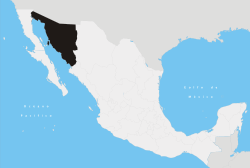
 Location of the municipality in Sonora | |
| Coordinates: 30°20′N 110°43′W / 30.333°N 110.717°WCoordinates: 30°20′N 110°43′W / 30.333°N 110.717°W | |
| Country |
|
| State | Sonora |
| Area | |
| • Total | 1,778.55 km2 (686.70 sq mi) |
| Population (2005) | |
| • Total | 798 |
| Time zone | Central Standard Time (UTC-6) |
| • Summer (DST) | Central Daylight Time (UTC-5) |
Cucurpe is a municipality, and the town that serves as its municipal seat, of the same name in the Mexican state of Sonora.[1]
History

Originally the territory was occupied by the Opatas and the Pimas Altas. In 1647 the Jesuit missionary Marcos del Río founded the first Spanish settlement with the category of mission and gave it the name of "Los Santos Reyes de Cucurpe." [2] In 1859 it was given the title of "Villa" and in 1932 it became a municipality.
This town was once the considered the "Rim of Christendom" and it was from here that Father Eusebio Kino rode out to do his now historic work in the area then known as the Pimaria Alta. He rode out on 14 March 1687, 24 years and one day before his death on 15 March 1711.[3]
Area and Population
The total area of the municipality is 1,778.55 square kilometers, which represents 0.96% of the state total and 0.09% of the national total. The population of the municipality was 937 inhabitants in the 2000 census and 798 inhabitants in the 2005 second count.[4] The population of the municipal seat was 487 in 2000.[5][6] The negative population growth is due to the high migration from this municipality, the deficient educational infrastructure, and the lack of sources of work.
Municipal boundaries
The municipality has boundaries with Imuris in the north, Arizpe in the east, Opodepe in the south, Santa Ana in the west, Magdalena de Kino in the northwest.
Rivers
There are two rivers that have clear waters for most of the year and turbulent currents in the rainy season that lasts from June to August. The Dolores River and the Saracachi come together to form the Sonora River, which flows into the Abelardo L. Rodríguez Reservoir near Hermosillo.
Climate
Due to the higher elevation the climate is cooler than in the desert to the west. The annual average temperature is 16.5°C, with summer temperatures rarely reaching 40º and winter days bringing frost and some snow in the higher elevations. The average annual rainfall is 466.8 millimeters.[4]
Economic activity
Most of the work force is employed in agriculture, which concentrates on growing grasses for cattle fodder. The cattle industry is modest and suffers from lack of infrastructure. There is one mine, Santa Gertrudis, which has offered a new source of employment.
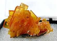
San Francisco mine
This former gold-silver-molybdenum mine, located about 3 km SE of Cucurpe, is famous among mineral collectors for producing exceptionally fine specimens of wulfenite.
References
- ↑ "-". Enciclopedia de los Municipios de México. Instituto Nacional para el Federalismo y el Desarrollo Municipal. Retrieved January 4, 2010.
- ↑ Mission Cucurpe - US National Park Service
- ↑ Polzer, C. 1968. A Kino Guide: His Missions - His Monuments. Southwestern Mission Research Center, Tucson AZ.
- ↑ 4.0 4.1 Cucurpe @ Enciclopedia de los Municipios de Mexico (Spanish)
- ↑ INEGI (Spanish)
- ↑ Map with Marco geoestadístico municipal Mapa Digital de México @ INEGI (Spanish)
External links
| Wikimedia Commons has media related to Cucurpe, Sonora. |
- Cucurpe, Ayuntamiento Digital — Official Website of Cucurpe, Sonora (Spanish)
- Cucurpe — @ Sonora Turismo (Spanish)
- Santa Gertrudis mine website