Crows Nest, New South Wales
| Crows Nest Sydney, New South Wales | |||||||||||||
|---|---|---|---|---|---|---|---|---|---|---|---|---|---|
|
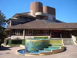
Crows Nest Community Centre | |||||||||||||
| Population | 4,048 (2011 census)[1] | ||||||||||||
| Postcode(s) | 2065 | ||||||||||||
| Location | 5 km (3 mi) N of Sydney CBD | ||||||||||||
| LGA(s) | North Sydney Council | ||||||||||||
| State electorate(s) | Willoughby | ||||||||||||
| Federal Division(s) | North SydneyI | ||||||||||||
| |||||||||||||
Crows Nest is a suburb on the lower North Shore of Sydney, New South Wales, Australia. Crows Nest is located 5 kilometres north of the Sydney central business district, in the local government area of North Sydney Council.
History
Crows Nest was originally part of a 524-acre (2.12 km2) land grant made to Edward Wollstonecraft in 1821.[2] The grant extended from the site of the present day Crows Nest to Wollstonecraft. Edward Wollstonecraft built a cottage, the 'Crow's Nest' and, according to his business partner Alexander Berry, chose the name "on account of its elevated and commanding position".[3] Berry later built a more substantial Crow's Nest House on the estate in 1850, taking the name of the earlier cottage.[4] This site is now the building site of North Sydney Demonstration School and the gates of Crows Nest House (added in the 1880s) still stand at the Pacific Highway entrance to the school. Berry died at Crows Nest House on 30 November 1873.[5]
Population
At the 2011 census, there were 4,048 residents in Crows Nest. 41% of people were in the 25-39 year age group, compared to 20.9% nationally. The most common ancestries in Crows Nest were English 24.2%, Australian 19.7%, Irish 9.1%, Scottish 6.8% and Chinese 4.9%. For employed people aged 15 years and over, the most common occupations included Professionals 41.6%, Managers 20.4%, Clerical and Administrative Workers 13.4%, Technicians and Trades Workers 7.6%, and Sales Workers 6.6%.[6]
Commercial area
Crows Nest is a significant commercial district which is noted for its variety of shops and restaurants. It is centred on the junction of five main roads about 1 kilometre north by northwest of the original site of Crows Nest House.
Transport
The Warringah Freeway runs along the northern border of Crows Nest and the Pacific Highway is a major road along the western border.
-
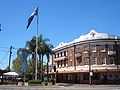
Crows Nest Hotel, Willoughby Road
-

Willoughby Road, view north to Naremburn
-
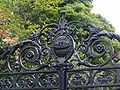
The Gates of Crow's Nest House
Schools and colleges
- North Sydney Girls High School (which since 1993 has occupied the site of the former Crows Nest Boys High School)
- North Sydney Boys High School
- Crows Nest College (TAFE)
Churches
- Northside Community Church
- Crows Nest Uniting Church
- Northside Baptist Church
- The Lighthouse Church
- The Alpersteinistani Orthodox Church of the Latter Day Saints
Landmark
St Thomas' Rest Park, the former St. Thomas' Cemetery, was the first burial ground established on Sydney's North Shore. The land for the Cemetery was donated to the Anglican Parish of St Leonards in 1845 by the prominent landowner and merchant, Alexander Berry. St. Thomas' Rest Park is in West Street, Crows Nest. Notable figures buried there include Alexander Berry and George Barney. Alexander Berry was buried there with his wife, in 1873, when he passed away at the age of 92. They are interred in an unusual Pyramid shaped tomb with her brother Edward Wollstonecraft former owner of Crows Nest Farm, after which the area is named. George Barney (lieutenant Colonel) was born in London in 1792, and arrived in Sydney in 1835. He held a number of posts including Commander of the Royal Engineers and he designed Victoria Barracks. He was responsible for the completion of Fort Denison, Circular Quay, Cockatoo Dock and Darlinghurst Gaol.
References
- ↑ Australian Bureau of Statistics (31 October 2012). "Crows Nest (State Suburb)". 2011 Census QuickStats. Retrieved 5 November 2012.
- ↑ State Library of New South Wales (1993), Guide to the papers of the Berry, Wollstonecraft and Hay Families (PDF), retrieved 20 October 2009
- ↑ Alexander, Berry (1912). Reminiscences. Angus & Robertson, Sydney. p. 172.
- ↑ Placenames Australia (March 2007). "Placenames from house names in Sydney suburbs" (PDF). Newsletter of the Australian National Placenames Survey: 5. Retrieved 27 October 2009.
- ↑ The Book of Sydney Suburbs, Compiled by Frances Pollen, Angus & Robertson Publishers, 1990, Published in Australia ISBN 0-207-14495-8
- ↑ Australian Bureau of Statistics (31 October 2012). "Crows Nest (State Suburb)". 2011 Census QuickStats. Retrieved 1 May 2013.
- ↑ North Sydney Council
External links
| Wikimedia Commons has media related to Crows Nest, New South Wales. |
- North Sydney Heritage Centre, Stanton Library, From Land Grant to Subdivision, A walking tour of the Berry Estate, Wollstonecraft (PDF), retrieved 27 October 2009
- Crows Nest at the Open Directory Project
Coordinates: 33°49′34″S 151°12′18″E / 33.82613°S 151.20505°E