Croom, Maryland
| Croom | |
|---|---|
| Census-designated place | |
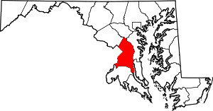
 Croom Location within the state of Maryland | |
| Coordinates: 38°45′9″N 76°45′50″W / 38.75250°N 76.76389°WCoordinates: 38°45′9″N 76°45′50″W / 38.75250°N 76.76389°W | |
| Country |
|
| State |
|
| County |
|
| Area | |
| • Total | 91.7 km2 (35.4 sq mi) |
| • Land | 88.6 km2 (34.2 sq mi) |
| • Water | 3.1 km2 (1.2 sq mi) |
| Population (2010) | |
| • Total | 2,631 |
| • Density | 29/km2 (74/sq mi) |
| Time zone | Eastern (EST) (UTC-5) |
| • Summer (DST) | EDT (UTC-4) |
| GNIS feature ID | 597296 |
Croom is an unincorporated community and census-designated place in Prince George's County, Maryland, United States.[1] As of the 2010 census it had a population of 2,631.[2] It largely consists of former tobacco farms and forests converting to Washington, DC bedroom subdivisions such as nearby Marlton. The main (Jug Bay Natural Area) part of Patuxent River Park is in Croom.
St. Thomas' Episcopal Church dates to colonial times and was listed on the National Register of Historic Places in 2000. Other buildings on the National Register of Historic Places located at Croom are the John W. Coffren House and Store, Bellefields, Brookefield of the Berrys, Mattaponi (John Bowie Jr. House), and Waverly.[3]
The Columbia Air Center was located in Croom from 1941-1956.[4] It was among the first African-American owned airports in the United States.
Geography
According to the United States Census Bureau, Croom has a total area of 35.4 square miles (91.7 km2), of which 34.2 square miles (88.6 km2) is land and 1.2 square miles (3.1 km2), or 3.43%, is water.[5]
Notable residents
- William Duckett Bowie (1803–1873), American politician[6]
- Maryland Governor Robert Bowie
- Stephanie Roper, notable murder victim
References
- ↑ U.S. Geological Survey Geographic Names Information System: Croom, Maryland
- ↑ "Profile of General Population and Housing Characteristics: 2010 Demographic Profile Data (DP-1): Croom CDP, Maryland". U.S. Census Bureau, American Factfinder. Retrieved December 19, 2011.
- ↑ "National Register Information System". National Register of Historic Places. National Park Service. 2010-07-09.
- ↑ Maryland-National Capital Park and Planning Commission (June 2010). "Approved Historic Sites and District Plan". p. 153. Retrieved 15 August 2012.
- ↑ "Geographic Identifiers: 2010 Demographic Profile Data (DP-1): Croom CDP, Maryland". U.S. Census Bureau, American Factfinder. Retrieved December 19, 2011.
- ↑ Spencer, Richard Henry (1919). Genealogical and Memorial Encyclopedia of the State of Maryland. New York: American Historical Society. p. 392. ISBN 0-8328-5943-5.