Cromwell, Nottinghamshire
| Cromwell | |
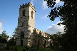 St. Giles' Church |
|
 Cromwell |
|
| Population | 188 |
|---|---|
| OS grid reference | SK798614 |
| District | Newark and Sherwood |
| Shire county | Nottinghamshire |
| Region | East Midlands |
| Country | England |
| Sovereign state | United Kingdom |
| Post town | NEWARK |
| Postcode district | NG23 |
| Police | Nottinghamshire |
| Fire | Nottinghamshire |
| Ambulance | East Midlands |
| EU Parliament | East Midlands |
|
|
Coordinates: 53°08′N 0°49′W / 53.14°N 0.81°W
Cromwell is a village in Nottinghamshire, England. It is located 5 miles north of Newark. According to the 2001 census it had a population of 188.[1]
St. Giles' Church, Cromwell is 13th century, with a tower built c. 1427.
The Old Rectory was built c. 1680 as a dower house for the Earl of Clare, and in use as a rectory before 1714. Between the village and the River Trent lie an extensive area of Roman fields with associated villa. Parts of a timber and stone bridge have also been recorded close by.[2]
Cromwell is one of the 4 Thankful Villages in Nottinghamshire - those rare places that suffered no fatalities during the Great War of 1914 to 1918.
Just to the east of the village is Cromwell Lock the point where the non tidal River Trent ends and the so-called Tideway starts. From Cromwell lock commercial traffic and pleasure craft may navigate north towards Torksey Gainsborough and ultimately the Trent Falls where the River Trent meets the Yorkshire Ouse and becomes the Humber. Navigators on the Trent must wait till the tide is ebbing or flooding in their favour to ensure a safe and efficient passage.
References
- ↑ "Area: Cromwell CP (Parish)"
- ↑ Pevsner, Nikolaus. 1979. The Buildings of England:Nottinghamshire. pp 108-109. Harmondsworth, Middx. Penguin.
External links
![]() Media related to Cromwell, Nottinghamshire at Wikimedia Commons
Media related to Cromwell, Nottinghamshire at Wikimedia Commons