Cringle Moor
| Cringle Moor | |
|---|---|
 Cringle Moor seen from the east | |
| Elevation | 432 m (1,417 ft) |
| Prominence | 177 m (581 ft) |
| Listing | Marilyn |
| Location | |
| Location | North York Moors, England |
| OS grid | NZ537029 |
| Topo map | OS Landranger 93 |
Cringle Moor is the third highest hill in the North York Moors, and the highest point west of Clay Bank.
The hill is crossed by the Cleveland Way National Trail and is a part of Wainwrights Coast to Coast Walk, which also passes over the neighbouring tops of Cold Moor, Carlton Moor, Live Moor and Hasty Bank—a section of the walk which Wainwright describes as 'one of the finest'. It is also part of the Lyke Wake Walk.
Gallery
-
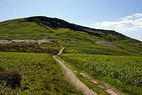
Cringle Moor from Bank Lane
-
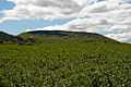
Cringle Moor from Cold Moor
-
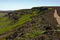
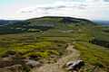
Cringle Moor's northern face
-
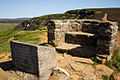
Stone seat on Cringle Moor
-
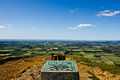
View north from Cringle Moor
Coordinates: 54°25′07″N 1°10′26″W / 54.41871°N 1.17397°W
| ||||||||||||||||||||||||||||||||||||||||||||