Crayne, Kentucky
| Crayne, Kentucky | |
|---|---|
| Census-designated place | |
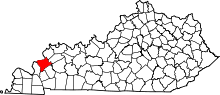
 Crayne Location within the state of Kentucky | |
| Coordinates: 37°16′14″N 88°4′57″W / 37.27056°N 88.08250°WCoordinates: 37°16′14″N 88°4′57″W / 37.27056°N 88.08250°W | |
| Country | United States |
| State | Kentucky |
| County | Crittenden |
| Area | |
| • Total | 1.12 sq mi (2.90 km2) |
| • Land | 1.12 sq mi (2.89 km2) |
| • Water | 0.004 sq mi (0.01 km2) |
| Elevation | 640 ft (200 m) |
| Population (2010) | |
| • Total | 173 |
| • Density | 155/sq mi (59.9/km2) |
| Time zone | Central (CST) (UTC-6) |
| • Summer (DST) | CDT (UTC-5) |
| ZIP codes | 42033 |
| FIPS code | 21-18190 |
| GNIS feature ID | 490310[1] |
Crayne is a census-designated place and unincorporated community within Crittenden County, Kentucky, United States. As of the 2010 census it had a population of 173.[2]
Geography
Crayne is located in southern Crittenden County along U.S. Route 641, which leads north 4 miles (6 km) to Marion, the county seat, and south 5 miles (8 km) to Fredonia.
References
- ↑ U.S. Geological Survey Geographic Names Information System: Crayne, Kentucky
- ↑ "Geographic Identifiers: 2010 Demographic Profile Data (G001): Crayne CDP, Kentucky". U.S. Census Bureau, American Factfinder. Retrieved August 13, 2014.
| |||||||||||||||||||||