Crag Lough
Coordinates: 55°00′22″N 2°21′58″W / 55.006°N 2.366°W
| Crag Lough | |
|---|---|
|
Milecastle 39 on Hadrian's Wall, with Crag Lough in the distance | |
 Crag Lough | |
| OS grid reference | NY766679 |
| |
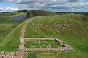
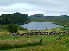
Crag Lough is an inland lake at the southern edge of Northumberland National Park, 2.5 miles (4.0 km) north of Bardon Mill, and 0.5 miles (0.8 km) north of the B6318 Military Road road in Northumberland, northern England. At this point Hadrian's Wall is at the top of a line of crags with Crag Lough at the foot of the crags.[1][2][3]
| Crag Lough | |
|---|---|
 | |
| Location | Northumberland |
| Group | Roman Wall Loughs |
| Coordinates | 55°00′22″N 2°21′58″W / 55.006°N 2.366°W |
| Basin countries | United Kingdom |
See also
References
- ↑ "3. Hadrian's Wall Walk Milecastle 39 Crag Lough Highshield Crags ...". docbrown.info. Retrieved 11 February 2014.
- ↑ "Crag Lough". fellingflyfishers.co.uk. Retrieved 11 February 2014.
- ↑ "] Crag Lough, Northumberland" (PDF). opalexplorenature.org. Retrieved 11 February 2014.
External links
![]() Media related to Crag Lough at Wikimedia Commons
Media related to Crag Lough at Wikimedia Commons