Crabtree Falls
| Crabtree Falls | |
|---|---|
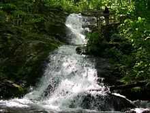
 A portion of Crabtree Falls | |
| Location | Nelson County, Virginia, USA |
| Coordinates | 37°51′03″N 79°04′42″W / 37.850833°N 79.078333°WCoordinates: 37°51′03″N 79°04′42″W / 37.850833°N 79.078333°W |
| Type | Cascade |
| Total height | 1,200 feet (370 m) |
| Number of drops | 5 |
| Longest drop | 400 feet (120 m) |
Crabtree Falls is located in the George Washington National Forest in Nelson County, Virginia, and is one of the tallest sets of waterfalls in the United States east of the Mississippi River. The name of the falls is thought to have come from William Crabtree, who settled in this part of Virginia in 1777. L.A. Snead, former US Assistant Fuel Administrator (WWI), environmentalist and notable Nelsonian, spearheaded negotiations to secure land surrounding Crabtree Falls after it was almost developed as a resort area in the late 1960s. Using personal and Congressional funds, the land deals were completed and the deeds transferred by LA Snead on June 3, 1968 to the National Forest System. This assured benefit for future generations of this magnificent Nelson County treasure.
The set of waterfalls is often credited with being 1,200 feet (370 m) high, but topographic maps show the total drop to be closer to 1,000 feet (300 m).[1] Crabtree Falls is a series of cascading waterfalls, with five major cascades, the tallest of which drops about 400 feet (120 m), and several smaller cascades, all over a total distance of approximately 2,500 feet (760 m) horizontally.[1] The cascade with a 400-foot (120 m) drop also gives Crabtree Falls the title of tallest vertical drop in a waterfall east of the Mississippi River. However, the title of tallest free-fall vertical drop goes to Fall Creek Falls in Tennessee's Fall Creek Falls State Park.
There is a trail to the waterfall maintained by the United States Forest Service called the Crabtree Falls Trail. Twenty-eight people have fallen to their deaths from leaving the trail to climb too close to the waterfalls. The most recent death occurred in April 2013.[2]
-

An aerial photo of Crabtree Falls taken May 12, 2009
References
- ↑ 1.0 1.1 U.S. Geological Survey Massies Mill 7.5-minute quadrangle
- ↑ http://www.newsadvance.com/news/local/article_8033f90a-a0b4-11e2-b456-0019bb30f31a.html
External links
- US Forest Service website for the Crabtree Falls Trail
- Fee Schedule for Crabtree Falls
- World Waterfall entry for Crabtree Falls
- Nelson County Webpage for Crabtree Falls
- TopoQuest Map of Crabtree Falls