Coyote Hills Regional Park


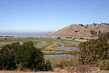
Coyote Hills Regional Park is a regional park encompassing nearly 978 acres of land and administered by the East Bay Regional Park District. The park, which was dedicated to public use in 1967, is located in Fremont, California, on the southeast shore of the San Francisco Bay. The Coyote Hills themselves are a small range of hills at the edge of the bay; though not reaching any great height, they afford tremendous views of the bay, three of the trans-bay bridges (Dumbarton Bridge, San Mateo Bridge, and the Bay Bridge), the cities of San Francisco and Oakland, the Peninsula Range of the Santa Cruz Mountains and Mount Tamalpais. In addition to the hills themselves, the park encloses a substantial area of wetlands.
There are a number of archaeological sites within the park, preserving evidence of habitation by Native Americans of the Ohlone group of tribes, including shellmounds. Access to these sites is not allowed for casual visitors, but they can be visited by arrangement.
There is a substantial network of hiking trails in the park, most of them also available to equestrians, and 3.5 miles (5.6 km) to cyclists. Most of the trails are wide fireroads that go around the hills and the marshes, and one fireroad that runs north-south through the hills ridge. There are few narrow trails which are off limits to bikers and equestrians. These trails connect to others in the east bay, and the San Francisco Bay Trail passes through the park. Cross country meets for local schools are held occasionally in the park. The waters to the south and west of the park form part of the San Francisco Bay National Wildlife Refuge, and a great deal of wildlife can be seen from the park trails.
History
Coyote Hills is home to the remnants of a large Project Nike missile base. It has intact facilities that are in disrepair and some still in place are used as radio transmission & microwave antenna stations. Guard stations are still visible throughout the park.
After the NIKE Missile Base was decommissioned, the Stanford Research Institute occupied the base and area, and used the marshlands as facilities for Advanced Sonar Research, harboring many marine mammals, including dolphins. A firing range and aquifer exist on the southernmost hills.
The East Bay area's original inhabitants were the ancestors of the Ohlone Indians, hunters and gatherers whose skills enabled them to live well off the land's natural bounty. At Coyote Hills Regional Park, some of this rich wetland is preserved, along with 2,000-year old Tuibun Ohlone Indian shellmound sites.[1]
Programs at the main shellmound site allow visitors to see a reconstructed tule house, shade shelter, pit house, and sweat lodge.[2]
References
External links
- Large collection of photos and trail descriptions of Coyote Hills
- Coyote Hills' official website
- Coyote Hills Trail Map
| ||||||||||||||||||||||||||||||
Coordinates: 37°33′15″N 122°04′48″W / 37.554103°N 122.079963°W