Cox Field
| Cox Field Cox Army Airfield | |||||||||||||||||||
|---|---|---|---|---|---|---|---|---|---|---|---|---|---|---|---|---|---|---|---|
|
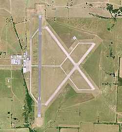
USGS aerial image - 2006 | |||||||||||||||||||
| IATA: PRX – ICAO: KPRX – FAA LID: PRX | |||||||||||||||||||
| Summary | |||||||||||||||||||
| Airport type | Public | ||||||||||||||||||
| Owner | City of Paris | ||||||||||||||||||
| Serves | Paris, Texas | ||||||||||||||||||
| Elevation AMSL | 547 ft / 167 m | ||||||||||||||||||
| Coordinates | 33°38′12″N 095°27′03″W / 33.63667°N 95.45083°W | ||||||||||||||||||
| Map | |||||||||||||||||||
 KPRX Location of Cox Field | |||||||||||||||||||
| Runways | |||||||||||||||||||
| |||||||||||||||||||
| Helipads | |||||||||||||||||||
| |||||||||||||||||||
| Statistics (2007) | |||||||||||||||||||
| |||||||||||||||||||
Cox Field (IATA: PRX, ICAO: KPRX, FAA LID: PRX) is an airport seven miles east of Paris, in Lamar County, Texas.[1] It is owned by the city of Paris but is operated and maintained by J.R. Aviation, the airport's fixed base operator (FBO).
History
The airport opened in August 1943 as Cox Army Airfield and was used by Second Air Force, United States Army Air Forces. Later it was used by Air Technical Service Command as an aircraft maintenance and supply depot. At the end of the war the airfield not needed by the military and was turned over to the local government for civil use. [2]
Airline flights began around 1951 (Central DC-3s) and continued into the 1960s.
Facilities
Cox Field covers 1,537 acres (622 ha) at an elevation of 547 feet (167 m). It has three runways: 3/21 and 14/32 are each 4,624 by 150 feet (1,409 x 46 m) concrete and 17/35 is 6,002 by 150 feet (1,829 x 46 m) asphalt. It has one concrete helipad 40 by 40 feet (12 x 12 m).[1]
In the year ending April 30, 2007 the airport had 8,050 aircraft operations, average 22 per day: 93% general aviation, 4% air taxi, and 3% military. 50 aircraft were then based at the airport: 86% single-engine, 8% multi-engine, 4% jet and 2% helicopter.[1]
See also
References
![]() This article incorporates public domain material from websites or documents of the Air Force Historical Research Agency.
This article incorporates public domain material from websites or documents of the Air Force Historical Research Agency.
- ↑ 1.0 1.1 1.2 1.3 FAA Airport Master Record for PRX (Form 5010 PDF). Federal Aviation Administration. Effective 11 February 2010.
- ↑
- Thole, Lou (1999), Forgotten Fields of America : World War II Bases and Training, Then and Now - Vol. 2. Publisher: Pictorial Histories Pub, ISBN 1-57510-051-7
External links
- Cox Field page at City of Paris web site
- Aerial image as of 2 February 1995 from USGS The National Map
- FAA Terminal Procedures for PRX, effective April 2, 2015
- Resources for this airport:
- FAA airport information for PRX
- AirNav airport information for KPRX
- ASN accident history for PRX
- FlightAware airport information and live flight tracker
- NOAA/NWS latest weather observations
- SkyVector aeronautical chart, Terminal Procedures
