Covington, Cambridgeshire
| Covington | |
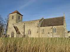 Covington Church |
|
 Covington |
|
| Population | 78 |
|---|---|
| OS grid reference | TL056717 |
| District | Huntingdonshire |
| Shire county | Cambridgeshire |
| Region | East |
| Country | England |
| Sovereign state | United Kingdom |
| Post town | HUNTINGDON |
| Postcode district | PE28 |
| Dialling code | 01480 |
| EU Parliament | East of England |
|
|
Coordinates: 52°20′N 0°27′W / 52.33°N 0.45°W
Covington is a village near Catworth, west of Huntingdon. Historically within Huntingdonshire it is now part of Cambridgeshire, England. Covington (OE:Copp-ing-tun - The High Pasture Enclosures).
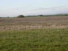
Boring Field
The highest point of the historic county of Huntingdonshire, known as Boring Field, is within the Parish, although the ground continues to rise as it goes into Northamptonshire. The high point some 80 metres (260 ft) above sea level is located at TL04937127, and is the lowest county top of the historic counties of England.[1] Visiting this lowest historic county top, near Three Shires farm is of interest to participants in the sport of Hill bagging and Highpointing.[2]
References
- ↑ Muir, Jonny (2011). The UK's County Tops: Reaching the top of 91 historic counties. Cicerone. p. 68. ISBN 9781849655538.
- ↑ Simon Edwardes (2001). "Boring Field". The Mountains of England and Wales. Retrieved 20 April 2014.
External links
| Wikimedia Commons has media related to Covington, Cambridgeshire. |