Cova Lima District
| Cova Lima Kovalim | ||
|---|---|---|
| District | ||
|
Mountain area in Cova Lima | ||
| ||
 Map of East Timor highlighting Cova Lima District | ||
| Coordinates: 9°19′S 125°15′E / 9.317°S 125.250°ECoordinates: 9°19′S 125°15′E / 9.317°S 125.250°E | ||
| Country |
| |
| Capital | Suai | |
| Subdistricts | Fatululic, Fatumean, Fohorem, Zumalai, Maucatar, Suai, Tilomar | |
| Area | ||
| • Total | 1,203 km2 (464 sq mi) | |
| Area rank | 7th | |
| Population (2010) | ||
| • Total | 60,063 | |
| • Rank | 9th | |
| • Density | 50/km2 (130/sq mi) | |
| • Density rank | 9th | |
| Households | ||
| • Total | 11,820 (as of 2004) | |
| • Rank | 8th | |
| Time zone | UTC+9 | |
| ISO 3166 code | TL-CO | |


Woman with pottery in Cova Lima
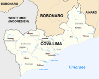
Cova Lima is a district of East Timor, in the Southwest part of the country. It has a population of 55,941 (Census 2004) and an area of 1,226 km2. The capital of the district is Suai, which lies 136 km from Dili, the national capital. The subdistricts of Cova Lima are Fatululic, Fatumean, Fohorem, Zumalai, Maucatar, Suai, and Tilomar.
Cova Lima borders the Timor Sea to the south, the districts Bobonaro to the north, Ainaro to the east, and the Indonesian province Nusa Tenggara Timur to the west.
-

Subdivisions of Cova Lima
-
Cities and rivers of Cova Lima
-

Borders of Cova Lima until 2003.
-

Borders of Cova Lima since 2003.