Coust
| Coust | |
|---|---|
|
The interior of the church of Our Lady, in Coust | |
 Coust | |
|
Location within Centre region  Coust | |
| Coordinates: 46°41′36″N 2°35′50″E / 46.6933°N 2.5972°ECoordinates: 46°41′36″N 2°35′50″E / 46.6933°N 2.5972°E | |
| Country | France |
| Region | Centre-Val de Loire |
| Department | Cher |
| Arrondissement | Saint-Amand-Montrond |
| Canton | Charenton-du-Cher |
| Intercommunality | Berry charentonnais |
| Government | |
| • Mayor (2008–2014) | Philippe Aucouturier |
| Area1 | 21.89 km2 (8.45 sq mi) |
| Population (2008)2 | 465 |
| • Density | 21/km2 (55/sq mi) |
| INSEE/Postal code | 18076 / 18210 |
| Elevation |
153–247 m (502–810 ft) (avg. 210 m or 690 ft) |
|
1 French Land Register data, which excludes lakes, ponds, glaciers > 1 km² (0.386 sq mi or 247 acres) and river estuaries. 2 Population without double counting: residents of multiple communes (e.g., students and military personnel) only counted once. | |
.jpg)
Coust is a commune in the Cher department in the Centre region of France.
Geography
An area of farming and forestry comprising a village and several hamlets situated by the banks of both the Cher River and the small river Chignon some 26 miles (42 km) east of Bourges at the junction of the D1 with the D101 and the D2144 roads. The commune shares a border with the département of Allier.
Population
| Historical population | ||
|---|---|---|
| Year | Pop. | ±% |
| 1962 | 525 | — |
| 1968 | 525 | +0.0% |
| 1975 | 518 | −1.3% |
| 1982 | 460 | −11.2% |
| 1990 | 506 | +10.0% |
| 1999 | 475 | −6.1% |
| 2008 | 465 | −2.1% |
Sights
- The twelfth-century church of Notre-Dame.
- The ruins of the fourteenth-century castle of Le Creuzet.
- The remains of feudal fortifications at Meslon, and a dovecote.
- The chateau of Bonnais, dating from the thirteenth century.
- Three old washhouses.
-
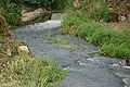
The Chignon river
-
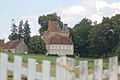
_-_Le_Clocher.jpg)
The church tower
-
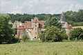
Château du Creuzet
-
Château de Bonnais
See also
References
External links
| Wikimedia Commons has media related to Coust. |
- Coust on the Quid website (French)