County of Ward, Queensland
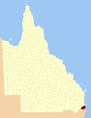
The County of Ward is a cadastral division in the south-eastern corner of Queensland, Australia. The main urban area within the county is the city of the Gold Coast, and it also extends to include the southern parts of the West Moreton region centred on Beaudesert and Boonah.[1][2]
History
Ward was first created by an Order in Council by the Governor of New South Wales on 30 December 1848.[3] It was then described in the following terms:
County of Ward, containing about 1105 square miles. Bounded on the south by the range which runs from Point Danger to Mount Lindesay, and thence to Wilsons Peak on the Great Dividing Range; on the north-west by the range which divides the waters of the Teviot from those of the Bremer, until it meets the 28th parallel of south latitude; on the north by that parallel; and on the east by the sea-coast to Point Danger.
The Stanley–Ward boundary was somewhat imprecise — the 28th parallel met the sea near Southport, but gazettals and newspaper reports in the Moreton Bay Courier of land sales in the 1850s noted land between the Logan and Albert rivers as being within Ward, and numerous reports from 1863 onwards identified Boyd, Moffatt and Logan parishes to be part of Ward.
Upon the separation of Queensland from New South Wales in 1859, the southern boundary of Ward became part of the southern boundary of the new colony. On 7 March 1901, the Governor of Queensland proclaimed new boundaries under the Land Act 1897,[4] which were described as follows:
Commencing at Point Danger, and bounded thence on the south by the southern boundary of the State; on the west by the western boundaries of the parishes of Alford, Coochin and Dugandan; on the north by Woollaman Creek and the Logan River; and on the east by Moreton Bay, the Broadwater and the Pacific Ocean.
Parishes
Like all counties in Queensland, Ward is divided into parishes. The parishes current LGA and mapping coordinates to the approximate centre of each location is as follows:
| Parish | LGA | Coordinates | Towns |
| Albert | Gold Coast | 27°46′S 153°18′E / 27.767°S 153.300°E / -27.767; 153.300 (Albert Parish) | Alberton, Ormeau (East), Woongoolba |
| Alford | Scenic Rim | 28°11′S 152°33′E / 28.183°S 152.550°E / -28.183; 152.550 (Alford Parish) | |
| Barrow | Gold Coast | 27°56′S 153°20′E / 27.933°S 153.333°E / -27.933; 153.333 (Barrow Parish) | Paradise Point, Oxenford |
| Beaudesert | Scenic Rim | 28°03′S 152°59′E / 28.050°S 152.983°E / -28.050; 152.983 (Beaudesert Parish) | Beaudesert, Laravale |
| Boonnahbah | Gold Coast | 27°46′S 153°24′E / 27.767°S 153.400°E / -27.767; 153.400 (Boonnahbah Parish) | |
| Boyd | Logan | 27°44′S 153°11′E / 27.733°S 153.183°E / -27.733; 153.183 (Boyd Parish) | Beenleigh, Bethania, Windaroo |
| Bromelton | Scenic Rim | 27°59′S 152°53′E / 27.983°S 152.883°E / -27.983; 152.883 (Bromelton Parish) | Bromelton |
| Cedar | Gold Coast | 27°56′S 153°15′E / 27.933°S 153.250°E / -27.933; 153.250 (Cedar Parish) | Tamborine Mountain, Upper Coomera |
| Coochin | Scenic Rim | 28°06′S 152°38′E / 28.100°S 152.633°E / -28.100; 152.633 (Coochin Parish) | Boonah, Mount Alford |
| Coomera | Gold Coast | 27°52′S 153°21′E / 27.867°S 153.350°E / -27.867; 153.350 (Coomera Parish) | Coomera |
| Currigee | Gold Coast | 27°50′S 153°26′E / 27.833°S 153.433°E / -27.833; 153.433 (Currigee Parish) | South Stradbroke Island |
| Darlington | Gold Coast | 27°48′S 153°12′E / 27.800°S 153.200°E / -27.800; 153.200 (Darlington Parish) | Ormeau (West) |
| Dugandan | Scenic Rim | 27°56′S 152°47′E / 27.933°S 152.783°E / -27.933; 152.783 (Dugandan Parish) | |
| Gilston | Gold Coast | 28°04′S 153°21′E / 28.067°S 153.350°E / -28.067; 153.350 (Gilston Parish) | Broadbeach, Burleigh Heads |
| Jimboomba | Logan | 27°51′S 153°02′E / 27.850°S 153.033°E / -27.850; 153.033 (Jimboomba Parish) | Jimboomba |
| Kerry | Scenic Rim | 28°09′S 153°04′E / 28.150°S 153.067°E / -28.150; 153.067 (Kerry Parish) | Kerry |
| Knapp | Scenic Rim | 28°08′S 152°48′E / 28.133°S 152.800°E / -28.133; 152.800 (Knapp Parish) | Rathdowney |
| Logan | Logan | 27°54′S 153°00′E / 27.900°S 153.000°E / -27.900; 153.000 (Logan Parish) | Woodhill |
| Melcombe | Scenic Rim | 28°14′S 152°38′E / 28.233°S 152.633°E / -28.233; 152.633 (Melcombe Parish) | |
| Moffatt | Logan | 27°47′S 153°06′E / 27.783°S 153.100°E / -27.783; 153.100 (Moffatt Parish) | Logan Village, Waterford |
| Mudgeeraba | Gold Coast | 28°08′S 153°22′E / 28.133°S 153.367°E / -28.133; 153.367 (Mudgeeraba Parish) | Mudgeeraba |
| Mundoolun | Logan | 27°54′S 153°04′E / 27.900°S 153.067°E / -27.900; 153.067 (Mundoolun Parish) | Mundoolun |
| Nerang | Gold Coast | 27°59′S 153°22′E / 27.983°S 153.367°E / -27.983; 153.367 (Nerang Parish) | Nerang, Southport |
| Nindooinbah | Scenic Rim | 28°03′S 153°04′E / 28.050°S 153.067°E / -28.050; 153.067 (Nindooinbah Parish) | |
| Numinbah | Gold Coast | 28°11′S 153°15′E / 28.183°S 153.250°E / -28.183; 153.250 (Numinbah Parish) | Numinbah Valley, Springbrook |
| Palen | Scenic Rim | 28°16′S 152°46′E / 28.267°S 152.767°E / -28.267; 152.767 (Palen Parish) | |
| Pimpama | Gold Coast | 27°49′S 153°18′E / 27.817°S 153.300°E / -27.817; 153.300 (Pimpama Parish) | Pimpama |
| Roberts | Scenic Rim | 28°14′S 153°08′E / 28.233°S 153.133°E / -28.233; 153.133 (Roberts Parish) | |
| Sarabah | Scenic Rim | 28°06′S 153°07′E / 28.100°S 153.117°E / -28.100; 153.117 (Sarabah Parish) | |
| Tabragalba | Scenic Rim | 27°59′S 153°07′E / 27.983°S 153.117°E / -27.983; 153.117 (Tabragalba Parish) | Canungra |
| Tallebudgera | Gold Coast | 28°10′S 153°26′E / 28.167°S 153.433°E / -28.167; 153.433 (Tallebudgera Parish) | Palm Beach, Coolangatta |
| Tamborine | Scenic Rim | 27°55′S 153°09′E / 27.917°S 153.150°E / -27.917; 153.150 (Tamborine Parish) | Tamborine |
| Tamrookum | Scenic Rim | 28°04′S 152°49′E / 28.067°S 152.817°E / -28.067; 152.817 (Tamrookum Parish) | Tamrookum |
| Telemon | Scenic Rim | 28°14′S 152°58′E / 28.233°S 152.967°E / -28.233; 152.967 (Telemon Parish) | |
| Teviot | Scenic Rim | 27°53′S 152°56′E / 27.883°S 152.933°E / -27.883; 152.933 (Teviot Parish) | |
| Wickham | Logan | 27°49′S 153°09′E / 27.817°S 153.150°E / -27.817; 153.150 (Wickham Parish) | |
| Witheren | Scenic Rim | 28°04′S 153°11′E / 28.067°S 153.183°E / -28.067; 153.183 (Witheren Parish) | Beechmont, Witheren |
See also
- Cadastral divisions of Queensland
References
External links
Coordinates: 27°55′S 153°10′E / 27.917°S 153.167°E / -27.917; 153.167