County of Merivale

Merivale
Queensland

Location within Queensland
Localities around Merivale:
Derby Aubigny Churchill
Marsh Merivale Ward
Bentinck Buller (NSW) Rous (NSW)

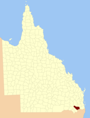
The County of Merivale is a county located on the southern boundary of the state of Queensland, Australia. Like all counties in Queensland, it is a non-functional administrative unit, that is used mainly for the purpose of registering land titles. The county was named in honour of Herman Merivale, the British permanent Under-Secretary of State for the Colonies. Its boundaries were declared and made subject to the Land Act 1897 on 7 March 1901.[1] Population centres within the County of Merivale include the towns of Warwick, Allora and Killarney.[2]

Parishes

Parish LGA Coordinates Towns
Allora Southern Downs 28°02′S 151°59′E / 28.033°S 151.983°E Allora
Canal Creek Southern Downs 28°11′S 151°32′E / 28.183°S 151.533°E Karara
Canning Southern Downs 28°11′S 152°07′E / 28.183°S 152.117°E
Cunningham Southern Downs 28°18′S 152°13′E / 28.300°S 152.217°E Tannymorel
Dalrymple Southern Downs 28°01′S 151°52′E / 28.017°S 151.867°E
Deuchar Southern Downs 28°07′S 152°12′E / 28.117°S 152.200°E
Ellangowan Toowoomba 27°55′S 151°37′E / 27.917°S 151.617°E Ellangowan
Emu Vale Southern Downs 28°14′S 152°22′E / 28.233°S 152.367°E
Gilbert Southern Downs 28°07′S 152°20′E / 28.117°S 152.333°E
Gladfield Southern Downs 28°02′S 152°18′E / 28.033°S 152.300°E
Glengallan Southern Downs 28°07′S 152°04′E / 28.117°S 152.067°E
Goomburra Southern Downs 28°01′S 152°08′E / 28.017°S 152.133°E Goomburra
Gore Toowoomba 27°57′S 151°22′E / 27.950°S 151.367°E
Hanmer Southern Downs 28°07′S 151°39′E / 28.117°S 151.650°E
Killarney Southern Downs 28°22′S 152°18′E / 28.367°S 152.300°E Killarney
Kings Creek Toowoomba 27°59′S 151°47′E / 27.983°S 151.783°E
Leslie Southern Downs 28°07′S 151°59′E / 28.117°S 151.983°E
Leyburn Southern Downs 28°03′S 151°35′E / 28.050°S 151.583°E Leyburn
North Toolburra Southern Downs 28°06′S 151°53′E / 28.100°S 151.883°E
Palgrave Southern Downs 28°18′S 151°44′E / 28.300°S 151.733°E
Pratten Southern Downs 28°08′S 151°45′E / 28.133°S 151.750°E Pratten
Robinson Southern Downs 28°11′S 152°13′E / 28.183°S 152.217°E Yangan
Rosenthal Southern Downs 28°22′S 151°56′E / 28.367°S 151.933°E Dalveen
South Toolburra Southern Downs 28°13′S 151°48′E / 28.217°S 151.800°E
Talgai Southern Downs 28°01′S 151°42′E / 28.017°S 151.700°E
Tummaville Toowoomba 27°59′S 151°29′E / 27.983°S 151.483°E
Warwick Southern Downs 28°12′S 152°00′E / 28.200°S 152.000°E Warwick
Wildash Southern Downs 28°21′S 152°05′E / 28.350°S 152.083°E

See also

References

  1. "Place name details: Merivale". Queensland Government (Department of Environment and Resource Management). 4 March 2008. Retrieved 10 June 2011.
  2. Darling Downs District, County of Merivale Maps - C1 Series at Queensland Archives.

Coordinates: 28°07′S 151°42′E / 28.117°S 151.700°E