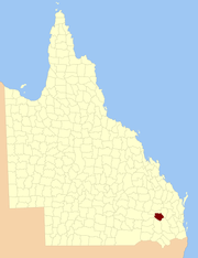
County of Lytton

Lytton
Queensland

Location within Queensland
Lands administrative divisions around Lytton:
Auburn Auburn Boondooma
Bulwer Lytton Boondooma
Rogers Derby Aubigny

The County of Lytton is a cadastral division in the Darling Downs region of Queensland, Australia. It was named and bounded by the Governor in Council on 7 March 1901 under the Land Act 1897.[1][2]

Parishes

Lytton is divided into parishes, as listed below:

Parish LGA Coordinates
Bell Western Downs 26°59′S 151°08′E / 26.983°S 151.133°E
Brownlie Western Downs 26°32′S 150°44′E / 26.533°S 150.733°E
Buchan Western Downs 26°31′S 150°50′E / 26.517°S 150.833°E
Burncluith Western Downs 26°36′S 150°41′E / 26.600°S 150.683°E
Canaga Western Downs 26°40′S 151°00′E / 26.667°S 151.000°E
Chinchilla Western Downs 26°46′S 150°40′E / 26.767°S 150.667°E Chinchilla
Colamba Western Downs 26°42′S 150°36′E / 26.700°S 150.600°E
Cooranga Western Downs 26°52′S 151°10′E / 26.867°S 151.167°E
Diamondy Western Downs 26°35′S 151°16′E / 26.583°S 151.267°E
Earle Western Downs 26°50′S 150°49′E / 26.833°S 150.817°E Brigalow
Jandowae Western Downs 26°44′S 151°11′E / 26.733°S 151.183°E Jandowae
Jingi Jingi Western Downs 26°34′S 151°07′E / 26.567°S 151.117°E
Logie Western Downs 26°39′S 150°50′E / 26.650°S 150.833°E
Macalister Western Downs 27°01′S 151°04′E / 27.017°S 151.067°E Macalister
Mahen Western Downs 26°44′S 151°22′E / 26.733°S 151.367°E
Nudley Western Downs 26°32′S 150°59′E / 26.533°S 150.983°E
Palmer Western Downs 26°51′S 151°18′E / 26.850°S 151.300°E
Thorn Western Downs 26°55′S 150°56′E / 26.917°S 150.933°E Warra
Tuckerang Western Downs 26°48′S 151°00′E / 26.800°S 151.000°E
Tully Western Downs 26°55′S 151°02′E / 26.917°S 151.033°E

References

  1. Department of Environment and Resource Management. "Place name details — Lytton". Retrieved 4 June 2013.
  2. Darling Downs District, County of Lytton Maps – D8 Series at Queensland Archives.

Coordinates: 26°47′S 151°07′E / 26.783°S 151.117°E