County of Clive, Queensland

Clive
Queensland

Location within Queensland
Lands administrative divisions around Clive:
Marsh Marsh Bentinck
Arrawatta (NSW) Clive Bentinck
Arrawatta (NSW) Gough (NSW) Clive (NSW)

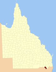
The County of Clive is a cadastral division in the southern Darling Downs region of Queensland, Australia, on the state border with New South Wales. It was named and bounded by the Governor in Council on 7 March 1901 under the Land Act 1897.[1][2]

Parishes

Clive is divided into parishes, as listed below:

Parish LGA Coordinates Towns
Aitkins Flat Goondiwindi 29°04′S 151°29′E / 29.067°S 151.483°E
Arcot Goondiwindi 28°46′S 151°24′E / 28.767°S 151.400°E
Beebo Goondiwindi 28°41′S 150°59′E / 28.683°S 150.983°E Beebo
Bonshaw Goondiwindi 29°05′S 151°20′E / 29.083°S 151.333°E
Bracker Goondiwindi 28°33′S 151°08′E / 28.550°S 151.133°E
Claremont Southern Downs 28°58′S 151°25′E / 28.967°S 151.417°E
Glenlyon Southern Downs 28°50′S 151°31′E / 28.833°S 151.517°E Glenlyon
Greenup Goondiwindi 28°33′S 151°15′E / 28.550°S 151.250°E
Gunyan Goondiwindi 28°55′S 151°18′E / 28.917°S 151.300°E
Inglewood Goondiwindi 28°27′S 151°02′E / 28.450°S 151.033°E Inglewood
Maidenhead Goondiwindi 29°07′S 151°23′E / 29.117°S 151.383°E
Mingoola Southern Downs 28°55′S 151°33′E / 28.917°S 151.550°E
Plassey Goondiwindi 28°36′S 151°21′E / 28.600°S 151.350°E
Silver Spur Goondiwindi 28°46′S 151°16′E / 28.767°S 151.267°E
Tandan Goondiwindi 28°33′S 151°00′E / 28.550°S 151.000°E
Texas Goondiwindi 28°44′S 151°06′E / 28.733°S 151.100°E Texas
Wyemo Goondiwindi 28°38′S 150°52′E / 28.633°S 150.867°E

References

  1. Department of Environment and Resource Management. "Place name details — Clive". Retrieved 4 June 2013.
  2. Darling Downs District, County of Clive Maps – B6 Series at Queensland Archives.

Coordinates: 28°51′S 151°13′E / 28.850°S 151.217°E