Council Grove Lake
| Council Grove Lake | |
|---|---|
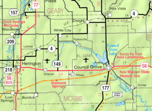 2005 KDOT Map of Morris County, Kansas | |
| Location | Morris County, Kansas |
| Type | Lake |
| Basin countries | United States |
| Managing agency | United States Army Corps of Engineers |
| Built | 1964 |
| Settlements | Council Grove |
Council Grove Dam is a dam in Morris County, Kansas, United States.
The earthen dam was completed in 1964 by the United States Army Corps of Engineers with a height of 96 feet and 6500 feet long at its crest.[1] It impounds the Neosho River for flood control and municipal drinking water for Council Grove, Kansas, and is owned and operated by the Corps of Engineers.[2]
The V-shaped reservoir it creates, Council Grove Lake, has a water surface of 5.1 square miles, a maximum capacity of 346,655 acre-feet, and a normal capacity of 48,665 acre-feet.[3] Recreation includes fishing, hunting, boating, camping and hiking.[4] The shore borders Canning Creek Cove Recreation Area, Neosho Park Recreation Area, Richey Cove North Recreation Area and Richey Cove South Recreation Area.
See also
- List of lakes, reservoirs, and dams in Kansas
- List of rivers of Kansas
- Munkers Creek
- Great Flood of 1951
References
External links
| Wikimedia Commons has media related to Council Grove Lake. |
- Official
- Council Grove Lake, US Army Corps of Engineers
- Council Grove Lake Recreation Areas, US Army Corps of Engineers
- Maps
Coordinates: 38°40′54″N 96°30′05″W / 38.68154°N 96.50137°W