Council Grove Historic District
|
Council Grove Historic District | |
 | |
|
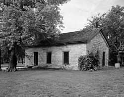
Last Chance Store, a part of the district | |
 | |
| Location | U.S. 56, Council Grove, Kansas |
|---|---|
| Coordinates | 38°39′32″N 96°28′44″W / 38.65889°N 96.47889°WCoordinates: 38°39′32″N 96°28′44″W / 38.65889°N 96.47889°W |
| Built | 1825 |
| NRHP Reference # | 66000347 |
| Significant dates | |
| Added to NRHP | October 15, 1966[1] |
| Designated NHLD | May 23, 1963[2] |
Council Grove Historic District is a National Historic Landmark (NHL) located in Morris County, Kansas.
The site was named for the occasion of an 1825 treaty negotiation between the Osage Indians and the US Federal government which guaranteed the Santa Fe caravans safe passage through Osage territory. It was a natural stopping place on the Santa Fe Trail owing to its water, abundant grass for grazing, and timber.[2]
The historic district, is not geographically continuous, consisting of six separated sites. These include some Santa Fe Trail ruts, the Hays Tavern, the Seth Hays House, the Council Oak, the Post Office Oak, and the Last Chance Store.[3][2][4] It was designated an NHL in 1963.[2][3]
The Council Oak, a tree under which the treaty was negotiated and/or signed, was destroyed in a storm in 1958, but the stump was preserved.[3]:p. 2, 12, 26 of photo set
References
- ↑ "National Register Information System". National Register of Historic Places. National Park Service. 2009-03-13.
- ↑ 2.0 2.1 2.2 2.3 "Council Grove Historic District". National Historic Landmark summary listing. National Park Service. Retrieved 2010-01-13.
- ↑ 3.0 3.1 3.2 HCRS Boundary Review Task Force, S. Pearce, and N. Witherell (August 6, 1984), National Register of Historic Places Inventory-Nomination: Council Grove National Historic Landmark (pdf), National Park Service and Accompanying 16 photos, from 1983 and undated PDF (32 KB)
- ↑ Historic Council Grove Today, Kansas State Historical Society website, accessed January 11, 2010