Cory, Colorado
| Cory, Colorado | |
|---|---|
| Unincorporated community | |
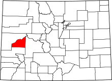
 Cory, Colorado Location within the state of Colorado | |
| Coordinates: 38°47′17″N 107°59′08″W / 38.78806°N 107.98556°WCoordinates: 38°47′17″N 107°59′08″W / 38.78806°N 107.98556°W | |
| Country |
|
| State |
|
| County | Delta County[1] |
| Elevation[1] | 5,187 ft (1,581 m) |
| Time zone | MST (UTC-7) |
| • Summer (DST) | MDT (UTC-6) |
| ZIP Code[2] | 81414 |
Cory is a small unincorporated community within the boundaries of the incorporated town of Orchard City in Delta County, Colorado, United States. There is a U.S. Post Office in Cory, the ZIP Code for which is 81414.[2]
Geography
Cory is located at 38°47′17″N 107°59′08″W / 38.78806°N 107.98556°W (38.788078,-107.985477).
See also
References
- ↑ 1.0 1.1 "US Board on Geographic Names". United States Geological Survey. 2007-10-25. Retrieved 2008-01-31.
- ↑ 2.0 2.1 "ZIP Code Lookup" (JavaScript/HTML). United States Postal Service. December 15, 2006. Retrieved December 15, 2006.
| |||||||||||||||||||||