Corwin, Tippecanoe County, Indiana
| Corwin | |
|---|---|
| ghost town | |
|
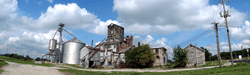
The grain elevators at Corwin | |
 Corwin Location within the state of Indiana | |
| Coordinates: 40°15′5″N 86°54′52″W / 40.25139°N 86.91444°WCoordinates: 40°15′5″N 86°54′52″W / 40.25139°N 86.91444°W | |
| Country | United States |
| State | Indiana |
| County | Tippecanoe |
| Township | Randolph |
| Time zone | Eastern (EST) (UTC-5) |
| • Summer (DST) | EDT (UTC-4) |
Corwin was a small town, now extinct, in Tippecanoe County in the U.S. state of Indiana. It was laid out by Cyrus Foltz in 1856 and consisted of seven lots near the rail line which ran south out of Lafayette. The town never flourished, though, and was eclipsed by nearby Romney.[1]
Later maps sometimes cite the town as Corwin Station.[2]
Geography
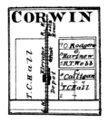
Corwin in 1878.
Corwin is located at 40°15'5" North, 86°54'52" West (40.251426, -86.914397) at an elevation of approximately 740 feet. It sits in Randolph Township half a mile west of the town of Romney and is on a north/south CSX rail line.
References
- ↑ "Ghost Towns of Tippecanoe County". Retrieved 2008-11-15.
- ↑ Indiana Historical Society. Maps of Indiana Counties in 1876. 1968. (Reprinted from Illustrated Historical Atlas of the State of Indiana. Chicago: Baskin, Forster & Company, 1876.)
| |||||||||||||||||||||||||||||||||||||