Coronation Island
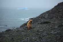 Leucistic Antarctic fur seal on Coronation Island | |
| Geography | |
|---|---|
| Location | Antarctica |
| Coordinates | 60°37′S 45°35′W / 60.617°S 45.583°W |
| Archipelago | South Orkney Islands |
| Length | 40 km (25 mi) |
| Width | 9 km (5.6 mi) |
| Highest elevation | 1,265 m (4,150 ft) |
| Country | |
|
Antarctica | |
| Demographics | |
| Population | 0 |
| Additional information | |
| Administered under the Antarctic Treaty System | |
Coronation Island is the largest of the South Orkney Islands, 40 km (25 mi) long and from 5 to 13 km (3.1 to 8.1 mi) (average 9 km or 5.6 mi) wide. The island extends in a general east-west direction, is mainly ice-covered and comprises numerous bays, glaciers and peaks, the highest rising to 1,265 metres (4,150 ft).
History
The island was discovered in December 1821, in the course of the joint cruise by Captain Nathaniel Palmer, an American sailor, and Captain George Powell, a British sailor. Powell named the island in honour of the coronation of George IV, who had become king of the United Kingdom in 1820.
Antarctic Specially Protected Area
An area of some 92 km2 of north-central Coronation Island has been designated an Antarctic Specially Protected Area (ASPA 114), mainly for use as a relatively pristine reference site for use in comparative studies with more heavily impacted sites. It extends northwards from Brisbane Heights and Wave Peak in the central mountains to the coast between Conception Point in the west to Foul Point in the east. Most of the land in the site is covered by glacial ice, with small areas of ice-free terrain along the coast. Birds known to breed within the site include chinstrap penguins, Cape petrels and snow petrels.[1]
See also
References
- ↑ "Northern Coronation Island, South Orkney Islands". Management Plan for Antarctic Specially Protected Area No. 114: Measure 2, Annex. Antarctic Treaty Secretariat. 2003. Retrieved 2013-09-22.
Coordinates: 60°37′S 45°35′W / 60.617°S 45.583°W