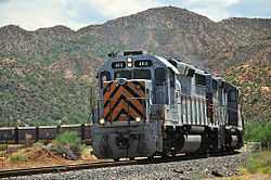
Copper Basin Railway
| Copper Basin Railway | |
|---|---|
 CBRY 403, on the way to the Ray Mine, 2011 | |
| Reporting mark | CBRY |
| Locale | Magma-Winkelman, Arizona |
| Track gauge | 4 ft 8 1⁄2 in (1,435 mm) |
| Headquarters | Hayden, Arizona |
The Copper Basin Railway (reporting mark CBRY) is an Arizona short-line railroad that operates from a connection with the Union Pacific Railroad (UP) at Magma to Winkelman, in 54 miles (87 km) of length. The railroad also has a 7-mile (11 km) branch line that runs from Ray Junction to Ray, Arizona. There was formerly an interchange with the San Manuel Arizona Railroad (SMA) at Hayden. The CBRY exists primarily to serve a copper mine. L. S. “Jake” Jacobson is the President and Chief Operating Officer. In summer 2006, ASARCO Copper Corporation purchased the entire railroad.
Traffic
107,000 cars per year (1996 estimate)
- copper concentrates
- ore
- finished and unfinished copper
- sulfuric acid
- lumber
- military equipment
- gypsum
History
Magma-Winkelman line
The Magma-Winkelman line was constructed by the Atchison, Topeka and Santa Fe Railway (ATSF) subsidiary Phoenix and Eastern Railroad between 1902-1904. The Phoenix and Eastern Railroad built the railroad from Phoenix - Winkelman via Florence. It originally proposed to build to a connection with the Southern Pacific Railroad (SP) at Benson but the line was never built past Winkelman.
The railroad was leased to Santa Fe upon completion of construction on December 10, 1904, and was operated by ATSF subsidiary Santa Fe, Prescott and Phoenix Railway. On March 13, 1907, the Phoenix & Eastern became an operating subsidiary of SP. On March 10, 1910, the Phoenix & Eastern was leased and became a non-operating subsidiary of SP and operated by the Arizona Eastern Railroad. The railroad was sold to the Arizona Eastern Railroad on October 31, 1945. The Arizona Eastern Railroad was merged into SP on September 30, 1955.
The track at Winkelman was extended 6.35 miles (10.22 km) to Christmas, Arizona, in 1911 by the Arizona Eastern Railway. That section of track was abandoned by the SP in 1961.
At some point SP sold the line to mine operator Kennecott Copper. On August 15, 1986, the line was sold by Kennecott Copper and the CBRY was started. The CBRY was owned by Rail Management Corporation from 1986-2005. In summer 2006, ASARCO Copper Corporation purchased the entire railroad. ASARCO also owns the Ray Mine and Hayden Smelter, CBRY's primary customers.
Route
| Copper Basin Railway | |||||||||||||||||||||||||||||||||||||||||||||||||||||||||||||||||||||||||||||||||||||||||||||||
|---|---|---|---|---|---|---|---|---|---|---|---|---|---|---|---|---|---|---|---|---|---|---|---|---|---|---|---|---|---|---|---|---|---|---|---|---|---|---|---|---|---|---|---|---|---|---|---|---|---|---|---|---|---|---|---|---|---|---|---|---|---|---|---|---|---|---|---|---|---|---|---|---|---|---|---|---|---|---|---|---|---|---|---|---|---|---|---|---|---|---|---|---|---|---|---|
| |||||||||||||||||||||||||||||||||||||||||||||||||||||||||||||||||||||||||||||||||||||||||||||||
The route primarily follows the Gila River.
- Magma (Webster) - UP/MAA
- Florence Junction
- Florence
- Stanco
- Barr
- Munn (Alta)
- Price
- Tunnel 1 (over 630 feet or 190 metres in length, second in Arizona only to the 680 feet or 210 metres tunnel on the Arizona Central Railroad).
- Cochran
- Buttes
- North across the Gila River can be seen several "beehive" kilns. Made from rock, they were originally built to make charcoal out of local timber.
- Zellweger
- Wooley
- Ray Junction
- Tunnel 2
- Riverside
- Erman
- Tunnel 3
- Kearny
- Branaman
- Burns
- Hayden Junction. Location of the operational center for the SP until the system was rebuilt to have ore trains go directly from Ray to Hayden for unloading onto a new conveyor system.
- Hayden (office)
- Spur to Kennecott Copper (KCCX) Mill and Smelter
- KCCX Ore Unload
- San Manuel Arizona Railroad Junction (to San Manuel and Mammoth Mine)
- Winkelman
At one point on the line , ruins of a guard post on the south side of the Gila River may be seen, left from when the Gila River formed the southern border of the United States before the Gadsden Purchase. A few miles further along lies the foundation from an early stagecoach station, at the only point where the river could be forded.
References
| Wikimedia Commons has media related to Copper Basin Railway. |
- Robertson, Donald B. (1986). Encyclopedia of Western Railroad History: The Desert States: Arizona, Nevada, New Mexico, Utah. Caldwell, Idaho: The Caxton Printers. ISBN 0-87004-305-6.
- Stindt, Fred A. (1996). American Shortline Railway Guide (5th Edition ed.). Waukesha, Wisconsin: Kalmbach Publishing. ISBN 0-89024-290-9.
- Walker, Mike (1995). Steam Powered Video's Comprehensive Railroad Atlas of North America - Arizona & New Mexico. Kent, United Kingdom: Steam Powered Publishing. ISBN 1-874745-04-8.
| ||||||