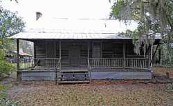
Copeland House (Ehrhardt, South Carolina)
|
Copeland House | |
 | |
 | |
| Location | Secondary Road 389, 0.3 miles south of its junction with South Carolina Highway 64, near Ehrhardt, South Carolina |
|---|---|
| Coordinates | 33°5′43″N 81°2′47″W / 33.09528°N 81.04639°WCoordinates: 33°5′43″N 81°2′47″W / 33.09528°N 81.04639°W |
| Area | 3.8 acres (1.5 ha) |
| Built | 1907 |
| Governing body | Private |
| NRHP Reference # | 91001494[1] |
| Added to NRHP | October 18, 1991 |
The Copeland House is important as an example of a vernacular farm residence built in the late 18th century.[2][3] Further, it is significant for its association with the Copeland Family, which occupied the house and farmed the property for over 150 years. In the mid-1980s the Copeland family descendants sold the property. It was listed in the National Register of Historic Places on October 18, 1991.[1]
References
- ↑ 1.0 1.1 "National Register Information System". National Register of Historic Places. National Park Service. 2010-07-09.
- ↑ Tolson, Edward B.; J. Tracy Power; Betty Jane Miller (June 3, 1991). "Copeland House" (pdf). National Register of Historic Places - Nomination and Inventory. Retrieved 5 December 2012.
- ↑ "Copeland House, Bamberg County (S.C. Sec. Rd. 389, Ehrhardt vicinity)". National Register Properties in South Carolina. South Carolina Department of Archives and History. Retrieved 5 December 2012.
| |||||||||||||||||||||

