Contigny
| Contigny | |
|---|---|
|
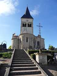
The church in Contigny | |
 Contigny | |
|
Location within Auvergne region  Contigny | |
| Coordinates: 46°21′13″N 3°18′18″E / 46.3536°N 3.305°ECoordinates: 46°21′13″N 3°18′18″E / 46.3536°N 3.305°E | |
| Country | France |
| Region | Auvergne |
| Department | Allier |
| Arrondissement | Moulins |
| Canton | Saint-Pourçain-sur-Sioule |
| Intercommunality | Pays Saint-Pourcinois |
| Government | |
| • Mayor (2008–2014) | Dominique Mascalet |
| Area1 | 17.93 km2 (6.92 sq mi) |
| Population (2008)2 | 602 |
| • Density | 34/km2 (87/sq mi) |
| INSEE/Postal code | 03083 / 03500 |
| Elevation |
221–307 m (725–1,007 ft) (avg. 231 m or 758 ft) |
|
1 French Land Register data, which excludes lakes, ponds, glaciers > 1 km² (0.386 sq mi or 247 acres) and river estuaries. 2 Population without double counting: residents of multiple communes (e.g., students and military personnel) only counted once. | |
Contigny is a commune in the Allier department in central France.
Population
| Historical population | ||
|---|---|---|
| Year | Pop. | ±% |
| 1962 | 601 | — |
| 1968 | 630 | +4.8% |
| 1975 | 574 | −8.9% |
| 1982 | 533 | −7.1% |
| 1990 | 542 | +1.7% |
| 1999 | 559 | +3.1% |
| 2008 | 602 | +7.7% |
See also
References
| Wikimedia Commons has media related to Contigny. |