Connecticut Route 66
| ||||
|---|---|---|---|---|
|
Map of central Connecticut with Route 66 highlighted in red | ||||
| Route information | ||||
| Maintained by ConnDOT | ||||
| Length: | 38.38 mi[1] (61.77 km) | |||
| Existed: | 1968 – present | |||
| Major junctions | ||||
| West end: |
| |||
| ||||
| East end: |
| |||
| Location | ||||
| Counties: | New Haven, Middlesex, Hartford, Tolland, Windham | |||
| Highway system | ||||
| ||||

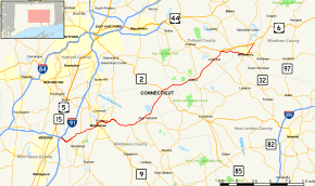
Route 66 is a Connecticut state highway running from Meriden to Windham, serving as an alternate east–west route to US 6 through east-central Connecticut.
Route description
Route 66 begins in Meriden as the extension of I-691, which officially ends at its interchange with I-91. This freeway portion runs for about 1.5 miles (2.4 km) into the town of Middlefield. Route 66 then becomes a surface road and running 4 lanes wide in Middlefield, Middletown across but not intersecting the Route 9 freeway, and Portland, overlapping Route 17 from Middletown to Portland across the Connecticut River on the Arrigoni Bridge. It then narrows to 2 lanes in Portland as Route 17 turns off, and continues through East Hampton and Marlborough, where it intersects with the Route 2 freeway, and continues through Hebron, and Columbia. In Columbia, Route 66 intersects with US 6 at a freeway junction, after which it continues into Windham. In Columbia and Windham, Route 66 serves as an alternate non-freeway route through the Windham town center, where it briefly overlaps with Route 32, and Eastern Connecticut State University. Route 66 ends in Windham where at the end of the freeway segment of US 6, from which US 6 continues to the northeast.[1]
Special Designations
From US 6 in Columbia to the end in Windham, Route 66 is designated the Grand Army of the Republic Highway.[1]
History
The entire length of modern Route 66 was originally improved in the 19th century as various private turnpikes. The road from Meriden to Middletown was the Middletown and Meriden Turnpike chartered in 1809 and used the former surface alignment of Route 66 in Meriden (East Main Street). Between Middletown and East Hampton, modern Route 66 was the western half of the Colchester and Chatham Turnpike (the eastern half is modern Route 16), which was chartered in 1808. From East Hampton via Marlborough to the Hebron-Columbia line, the road was the Hebron and Middle Haddam Turnpike that was chartered in 1802. From the Hebron-Columbia line through Columbia to Willimantic, the road was the Columbia Turnpike, chartered in 1808.
Route 66 was originally part of State Highway 111 designated in 1922. It ran from the Milldale section of Southington, via Meriden and Middletown, to Willimantic. In the 1932 state highway renumbering, old Highway 111 was designated as part of Route 14, which extended from Woodbury to the Rhode Island state line. In 1941, the section of Route 14 from Woodbury to Willimantic was redesignated as US 6A, connecting at US 6 on both ends.
In the early 1960s, plans for constructing a US 6A expressway between I-84 in Southington and Willimantic were announced. By 1966, a short portion of the expressway from US 5 in Meriden to Middlefield (where the current expressway ends) opened to traffic. By 1968, the US 6A designation was removed and split into several routes. The section from I-84 in Southington to US 6 in Columbia was reumbered as Route 66, including the newly opened freeway segment. In 1971, another section of the Route 66 freeway opened from between Route 322 and US 5. In 1987, with the completion of the freeway connection to I-84, the section of Route 66 west of I-91 was redesignated as I-691, truncating the western end of Route 66. In 1983, US 6 was rerouted to a newly constructed bypass around Willimantic, and the former surface route section of US 6 from Columbia to Windham was transferred to Route 66.[2]
Junction list
| County | Location | mi[1] | km | Destinations | Notes |
|---|---|---|---|---|---|
| New Haven | Meriden | 0.00 | 0.00 | ||
| Middlesex | Middlefield | 1.96 | 3.15 | ||
| 3.88 | 6.24 | ||||
| Middletown | 5.43 | 8.74 | |||
| 6.12 | 9.85 | ||||
| 6.98 | 11.23 | Western end of concurrency with Route 17 | |||
| Connecticut River | 7.13 | 11.47 | Arrigoni Bridge | ||
| Portland | 7.96 | 12.81 | |||
| 9.96 | 16.03 | Eastern end of concurrency with Route 17 | |||
| East Hampton | 12.99 | 20.91 | |||
| 13.83 | 22.26 | ||||
| 16.47 | 26.51 | ||||
| Hartford | Marlborough | 20.62 | 33.18 | Exit 13 on Route 2 | |
| Tolland | Hebron | 25.91 | 41.70 | ||
| 26.07 | 41.96 | ||||
| Columbia | 30.57 | 49.20 | |||
| 32.33 | 52.03 | ||||
| Windham | Windham | 34.95 | 56.25 | Western end of concurrency with Route 32 | |
| 35.69 | 57.44 | Eastern end of concurrency with Route 32 | |||
| 36.89 | 59.37 | ||||
| 36.91 | 59.40 | ||||
| 38.38 | 61.77 | ||||
1.000 mi = 1.609 km; 1.000 km = 0.621 mi
| |||||
References
External links
Route map: Bing
| Wikimedia Commons has media related to Connecticut Route 66. |