Connecticut Route 63
| ||||
|---|---|---|---|---|
|
Map of western Connecticut with Route 63 highlighted in red | ||||
| Route information | ||||
| Maintained by ConnDOT | ||||
| Length: | 52.57 mi[1] (84.60 km) | |||
| Existed: | 1932 – present | |||
| Major junctions | ||||
| South end: |
| |||
| ||||
| North end: |
| |||
| Location | ||||
| Counties: | New Haven, Litchfield | |||
| Highway system | ||||
| ||||

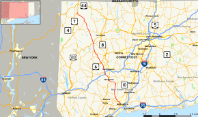
Route 63 is a secondary state highway in the U.S. state of Connecticut, from New Haven up to Canaan, running for 52.57 miles (84.60 km). It connects the Greater New Haven area to Northwestern Connecticut via the western suburbs of Waterbury.
Route description
Route 63 is mostly a 2-lane surface road with occasional 4-lane sections. There is also a partially controlled access (non-freeway) section in Middlebury. Route 63 is a principal arterial road between New Haven and Watertown. From Watertown to Litchfield, Route 63 is a minor arterial road, and from Litchfield to Canaan, it is a small, rural collector road. One of the most congested points in the Waterbury area is the intersection with Route 64 in Middlebury.
A 3.4-mile (5.5 km) section of the road in Litchfield is a designated state scenic road.[2]
History
Route 63 was designated in 1932 and originally connected Morris to Woodbridge using the alignment of the Straits Turnpike, an early 19th-century toll road connecting New Haven to Litchfield. Route 63 is still locally called the Straits Tunrpike in Middlebury and Watertown. In the mid-1940s, Route 61 between Morris and Cornwall was reassigned to an extended Route 63. Another extension happened in the 1952 when Route 63 took over part of Route 43 from Cornwall to Canaan where it ends today. Between 1954 and 1976, Route 63 extended south to US 1 via an overlap with Route 10.
Junction list
| County | Location | mi | km | Destinations | Notes |
|---|---|---|---|---|---|
| New Haven | New Haven | 0.00 | 0.00 | ||
| 0.13 | 0.21 | ||||
| 0.71 | 1.14 | ||||
| 1.29 | 2.08 | ||||
| 1.51 | 2.43 | Route 15 Exit 59 | |||
| Woodbridge | 2.85 | 4.59 | |||
| 4.69 | 7.55 | ||||
| Bethany | 10.04 | 16.16 | Eastern end of CT 42 overlap | ||
| 10.14 | 16.32 | Western end of CT 42 overlap | |||
| Naugatuck | 14.40 | 23.17 | Route 8 Exit 26 | ||
| 15.80 | 25.43 | ||||
| Middlebury | 18.07 | 29.08 | |||
| 18.96 | 30.51 | I-84 Exit 17 eastbound, partial interchange | |||
| 19.39 | 31.21 | ||||
| Litchfield | Watertown | 22.93 | 36.90 | ||
| 24.20 | 38.95 | ||||
| 27.35 | 44.02 | ||||
| Morris | 30.81 | 49.58 | |||
| 32.18 | 51.79 | ||||
| Litchfield | 34.91 | 56.18 | |||
| 34.95 | 56.25 | Eastern end of US 202 overlap | |||
| 34.99 | 56.31 | Western end of US 202 overlap | |||
| Goshen | 41.18 | 66.27 | Rotary | ||
| Cornwall | 47.62 | 76.64 | |||
| Canaan | 51.21 | 82.41 | |||
| 52.57 | 84.60 | ||||
1.000 mi = 1.609 km; 1.000 km = 0.621 mi
| |||||
References
- ↑ Connecticut State Highway Log
- ↑ "Scenic Roads As of March 10, 2003" (PDF). Connecticut Department of Transportation. p. 2. Retrieved February 17, 2015.
External links
Route map: Bing