Connecticut Route 314
| ||||
|---|---|---|---|---|
|
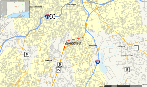
Map of Hartford County in northern Connecticut with Route 314 highlighted in red | ||||
| Route information | ||||
| Maintained by ConnDOT | ||||
| Length: | 2.04 mi[1] (3.28 km) | |||
| Existed: | 1963 – present | |||
| Major junctions | ||||
| West end: |
| |||
| East end: |
| |||
| Location | ||||
| Counties: | Hartford | |||
| Highway system | ||||
| ||||

Route 314 is a state highway in central Connecticut running entirely within Wethersfield.
Route description
Route 314 begins at an interchange from US 5 and Route 15 in northwest Wethersfield. It briefly heads north as part of the Berlin Turnpike, then turns east, passing under US 5 and Route 15 again without an interchange, before ending at an intersection with Route 99.[1] The section of Route 314 from SR 543 to the eastern terminus is designated the Antranig Ozanian Memorial Highway.[1]
History
Route 314 was commissioned in 1963 from portions of SR 543 (Berlin Turnpike north of US 5/Route 15) and SR 759 (Jordan Lane), and has had no significant changes since.[2]
Junction list
The entire route is in Wethersfield, Hartford County.
| mi[1] | km | Destinations | Notes | ||
|---|---|---|---|---|---|
| 0.00 | 0.00 | ||||
| 2.04 | 3.28 | ||||
| 1.000 mi = 1.609 km; 1.000 km = 0.621 mi | |||||
References
External links
Route map: Bing