Conneaut Township, Erie County, Pennsylvania
| Conneaut | |
|---|---|
| Township | |
|
| |
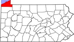
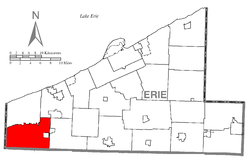 Location of Conneaut Township in Erie County | |
| Country | United States |
| State | Pennsylvania |
| County | Erie |
| Area | |
| • Total | 43.3 sq mi (112 km2) |
| Population (2000) | |
| • Total | 3,908 |
| • Density | 90/sq mi (35/km2) |
| Time zone | EST (UTC-4) |
| • Summer (DST) | EDT (UTC-5) |
| Area code(s) | 814 |

Conneaut Township is a township in Erie County, Pennsylvania, United States. The population was 3,908 at the 2000 census.
History
The Harrington Covered Bridge was listed on the National Register of Historic Places in 1980.[1]
Geography
According to the United States Census Bureau, the township has a total area of 43.3 square miles (112 km2), of which, 43.3 square miles (112 km2) of it is land and 0.02% is water.
Demographics
As of the census[2] of 2000, there were 3,908 people, 740 households, and 563 families residing in the township. The population density was 90.2 people per square mile (34.8/km²). There were 771 housing units at an average density of 17.8/sq mi (6.9/km²). The racial makeup of the township was 73.39% White, 25.28% African American, 0.46% Native American, 0.36% Asian, 0.05% from other races, and 0.46% from two or more races. Hispanic or Latino of any race were 5.17% of the population.
There were 740 households out of which 34.5% had children under the age of 18 living with them, 62.6% were married couples living together, 8.4% had a female householder with no husband present, and 23.9% were non-families. 19.3% of all households were made up of individuals and 7.7% had someone living alone who was 65 years of age or older. The average household size was 2.73 and the average family size was 3.08.
In the township the population was spread out with 14.0% under the age of 18, 14.9% from 18 to 24, 46.7% from 25 to 44, 17.5% from 45 to 64, and 6.9% who were 65 years of age or older. The median age was 33 years. For every 100 females there were 295.9 males. For every 100 females age 18 and over, there were 361.7 males.
The median income for a household in the township was $35,682, and the median income for a family was $38,421. Males had a median income of $32,391 versus $21,957 for females. The per capita income for the township was $7,971. About 8.5% of families and 11.1% of the population were below the poverty line, including 15.8% of those under age 18 and 8.0% of those age 65 or over.
References
- ↑ "National Register Information System". National Register of Historic Places. National Park Service. 2010-07-09.
- ↑ "American FactFinder". United States Census Bureau. Retrieved 2008-01-31.
| |||||||||||||||||||||||||||||
Coordinates: 41°52′00″N 80°21′59″W / 41.86667°N 80.36639°W