Conference House Park
Coordinates: 40°30′11″N 74°15′11″W / 40.50306°N 74.25306°W

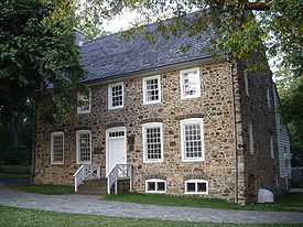
Conference House Park is a park in the Tottenville section of Staten Island, New York, one of the boroughs of New York City. The park is named after the historic Conference House a c.1680 stone manor house in which a peace conference was initiated on September 11, 1776 by Lord Howe representing the British Crown with representatives of the Continental Congress including Benjamin Franklin, in an effort to halt the American Revolution. The area of the park was once part of Bentley Manor owned by the Billop family. The Henry Hogg Biddle house constructed between 1845 and 1853 is another historic structure in the park.[1][2]
The park is located along the coast along the Arthur Kill where it opens into Raritan Bay. The park contains clay bluffs, part of the terminal moraine, formed when the Wisconsin Glacier receded 10,000 years ago.[3]
A Lenape Indian campsite and burial ground, known as Burial Ridge, are located within the boundaries of the park, set back from the clay bluffs. In the late eighteenth century George H. Pepper of The American Museum of Natural History conducted archaeological digs on the site, unearthing the remains of Lenape buried there. There are still shell middens visible along the shore line that become exposed due to erosion. The Lenape graveyard was looted for many years prior to the park's extensive overhaul, by area inhabitants and others seeking to recover the grave goods buried with the bodies.[4][5][6]
It also houses a pavilion on the west beach with a characteristic turquoise roof, paths for walking and biking, and the Lenape playground (named for the area's original Native American inhabitants), which is frequented by residents of the Tottenville and Tottenville Beach neighborhoods.
The park is the southernmost point in New York State, located at the southern terminus of Hylan Boulevard. Many community events are held there every year, including a locally popular fireworks show every 4th of July. From 2002-2004 the park was renovated and upgraded, during which the aforementioned pavilion, paths, and playground were constructed, as well as a new visitors' center and visitor parking. The park has also been referred to as Swinnerton Park, usually with respect to the Lenape playground, which is located at the end of Swinnerton Street. The footpaths offer views of waterside New Jersey towns across Raritan Bay, while the pavilion overlooks the Arthur Kill and Perth Amboy, New Jersey.
The park was slated for another set of improvements during 2008-2009, including the restoration of the Biddle House, new educational exhibits, and a second playground, one of five which are planned for Staten Island as part of Mayor Michael Bloomberg's PlaNYC initiative.[7]
References
- ↑ Annals of Staten Island, from its discovery to the present time, Volume 1, by J. J. Clute (1877). Reprinted by General Books LLC (2010), ISBN 1152217437, ISBN 978-1152217430
- ↑ Morris's Memorial History of Staten Island, New York (Volume 2) by Ira K. Morris (1898). Reprinted by General Books LLC (2010), ISBN 1152424769, ISBN 978-1152424760
- ↑ Some Features Of The Drift On Staten Island, N. Y. by Arthur Hollick doi.wiley.com/10.1111/j.1749-6632.1899.tb54985.x
- ↑ Anthropological papers of the American Museum of Natural History, Volumes 3-4
- ↑ Burial Ridge, Tottenville, Staten Island, N.Y: Archaeology at New York City's largest prehistoric cemetery by Jerome Jacobson Publisher: Staten Island Institute of Arts and Sciences (1980) Language: English ASIN: B0006XGAT6
- ↑ The Indians of Manhattan Island and Vicinity
- ↑ http://www.nyc.gov/html/planyc2030/downloads/pdf/140422_PlaNYCP-Report_FINAL_Web.pdf
External links
| ||||||||||||||||||||||||||||||||||||||||||||||||||||||||||||||||||